|
|
|||||||||||||||||
| Point ID: 313 | Downloads | Plots | Site Data | Code: 05BL016 |
|
|
|||||||||||||||||
| Download | |
|---|---|
| Site Descriptor Information | Site Time Series Data |
| Link to all available data | |
| View: | Time Series | All |
| Units: | m3/s |
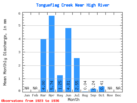
| Statistic | Jan | Feb | Mar | Apr | May | Jun | Jul | Aug | Sep | Oct | Nov | Dec | Annual |
|---|---|---|---|---|---|---|---|---|---|---|---|---|---|
| Mean | 4.00 | 5.74 | 1.26 | 4.80 | 2.55 | 0.04 | 0.24 | 0.41 | |||||
| Standard Deviation | 3.75 | 3.26 | 0.99 | 5.66 | 2.51 | 0.23 | 0.08 | ||||||
| Min | 0.69 | 0.95 | 0.58 | 0.81 | 0.77 | 0.04 | 0.08 | 0.35 | |||||
| Max | 9.06 | 9.62 | 2.99 | 14.66 | 4.32 | 0.04 | 0.40 | 0.46 | |||||
| Coefficient of Variation | 0.94 | 0.57 | 0.79 | 1.18 | 0.98 | 0.95 | 0.19 |
 Return to R-Arctic Net Home Page