|
|
|||||||||||||||||
| Point ID: 3125 | Downloads | Plots | Site Data | Code: 06EC002 |
|
|
|||||||||||||||||
| Download | |
|---|---|
| Site Descriptor Information | Site Time Series Data |
| Link to all available data | |
|
|
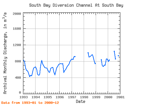
| View: | Statistics | Time Series |
| Units: | mm |
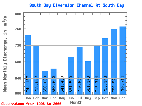
| Statistic | Jan | Feb | Mar | Apr | May | Jun | Jul | Aug | Sep | Oct | Nov | Dec | Annual |
|---|---|---|---|---|---|---|---|---|---|---|---|---|---|
| Mean | 744.17 | 719.67 | 658.00 | 663.60 | 641.40 | 691.50 | 716.57 | 681.14 | 719.71 | 737.14 | 759.57 | 765.71 | 625.27 |
| Standard Deviation | 104.69 | 125.55 | 173.80 | 173.96 | 215.48 | 150.90 | 220.84 | 182.76 | 202.52 | 160.90 | 116.98 | 110.21 | 50.32 |
| Min | 585.00 | 537.00 | 480.00 | 458.00 | 470.00 | 505.00 | 416.00 | 455.00 | 443.00 | 535.00 | 630.00 | 634.00 | 583.92 |
| Max | 859.00 | 844.00 | 915.00 | 917.00 | 1010.00 | 903.00 | 1040.00 | 939.00 | 997.00 | 993.00 | 935.00 | 928.00 | 696.08 |
| Coefficient of Variation | 0.14 | 0.17 | 0.26 | 0.26 | 0.34 | 0.22 | 0.31 | 0.27 | 0.28 | 0.22 | 0.15 | 0.14 | 0.08 |
| Year | Jan | Feb | Mar | Apr | May | Jun | Jul | Aug | Sep | Oct | Nov | Dec | Annual | 1993 | 830.00 | 770.00 | 632.00 | 579.00 | 564.00 | 505.00 | 416.00 | 455.00 | 443.00 | 535.00 | 630.00 | 648.00 | 583.92 | 1994 | 664.00 | 597.00 | 480.00 | 458.00 | 470.00 | 679.00 | 819.00 | 732.00 | 686.00 | 651.00 | 634.00 | 634.00 | 625.33 | 1995 | 585.00 | 537.00 | 529.00 | 624.00 | 642.00 | 652.00 | 539.00 | 459.00 | 545.00 | 642.00 | 676.00 | 719.00 | 595.75 | 1996 | 734.00 | 741.00 | 734.00 | 740.00 | 521.00 | 578.00 | 595.00 | 660.00 | 694.00 | 728.00 | 793.00 | 835.00 | 696.08 | 1997 | 859.00 | 844.00 | 915.00 | 917.00 | 1998 | 1010.00 | 903.00 | 917.00 | 939.00 | 965.00 | 913.00 | 791.00 | 742.00 | 1999 | 832.00 | 690.00 | 668.00 | 708.00 | 698.00 | 858.00 | 854.00 | 2000 | 793.00 | 829.00 | 1040.00 | 855.00 | 997.00 | 993.00 | 935.00 | 928.00 |
|---|
 Return to R-Arctic Net Home Page