|
|
|||||||||||||||||
| Point ID: 3111 | Downloads | Plots | Site Data | Code: 05UE004 |
|
|
|||||||||||||||||
| Download | |
|---|---|
| Site Descriptor Information | Site Time Series Data |
| Link to all available data | |
|
|
| View: | Statistics | Time Series |
| Units: | mm |
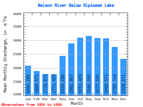
| Statistic | Jan | Feb | Mar | Apr | May | Jun | Jul | Aug | Sep | Oct | Nov | Dec | Annual |
|---|---|---|---|---|---|---|---|---|---|---|---|---|---|
| Mean | 2084.29 | 1888.57 | 1778.57 | 1771.43 | 2434.29 | 2882.86 | 3091.43 | 3160.00 | 3077.50 | 3068.57 | 2755.71 | 2328.57 | 2596.39 |
| Standard Deviation | 414.44 | 317.62 | 272.12 | 232.91 | 411.17 | 439.61 | 487.49 | 462.66 | 433.88 | 309.86 | 358.83 | 419.54 | 277.62 |
| Min | 1640.00 | 1530.00 | 1500.00 | 1590.00 | 2030.00 | 2310.00 | 2250.00 | 2280.00 | 2260.00 | 2700.00 | 2270.00 | 1840.00 | 2290.83 |
| Max | 2830.00 | 2460.00 | 2240.00 | 2180.00 | 3090.00 | 3510.00 | 3800.00 | 3780.00 | 3580.00 | 3530.00 | 3370.00 | 3110.00 | 3020.00 |
| Coefficient of Variation | 0.20 | 0.17 | 0.15 | 0.13 | 0.17 | 0.15 | 0.16 | 0.15 | 0.14 | 0.10 | 0.13 | 0.18 | 0.11 |
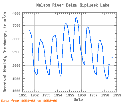
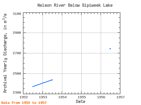
| Year | Jan | Feb | Mar | Apr | May | Jun | Jul | Aug | Sep | Oct | Nov | Dec | Annual | 1951 | 3310.00 | 3180.00 | 3110.00 | 2550.00 | 2010.00 | 1952 | 1770.00 | 1700.00 | 1650.00 | 1710.00 | 2610.00 | 2860.00 | 2980.00 | 2910.00 | 2860.00 | 2720.00 | 2520.00 | 2150.00 | 2370.00 | 1953 | 1910.00 | 1760.00 | 1670.00 | 1650.00 | 2090.00 | 2500.00 | 2940.00 | 3100.00 | 3100.00 | 3120.00 | 2980.00 | 2430.00 | 2437.50 | 1954 | 2120.00 | 1840.00 | 1610.00 | 1590.00 | 2180.00 | 2870.00 | 3270.00 | 3540.00 | 3570.00 | 3530.00 | 3370.00 | 3110.00 | 2716.67 | 1955 | 2830.00 | 2460.00 | 2240.00 | 2180.00 | 3090.00 | 3510.00 | 3800.00 | 3780.00 | 3580.00 | 3360.00 | 2860.00 | 2550.00 | 3020.00 | 1956 | 2420.00 | 2170.00 | 2080.00 | 2020.00 | 2830.00 | 3400.00 | 3450.00 | 3410.00 | 3250.00 | 2940.00 | 2740.00 | 2210.00 | 2743.33 | 1957 | 1900.00 | 1760.00 | 1700.00 | 1660.00 | 2210.00 | 2730.00 | 2950.00 | 2950.00 | 2820.00 | 2700.00 | 2270.00 | 1840.00 | 2290.83 | 1958 | 1640.00 | 1530.00 | 1500.00 | 1590.00 | 2030.00 | 2310.00 | 2250.00 | 2280.00 | 2260.00 |
|---|
 Return to R-Arctic Net Home Page