|
|
|||||||||||||||||
| Point ID: 3107 | Downloads | Plots | Site Data | Code: 05UB010 |
|
|
|||||||||||||||||
| Download | |
|---|---|
| Site Descriptor Information | Site Time Series Data |
| Link to all available data | |

|
|
| View: | Statistics | Time Series |
| Units: | mm |
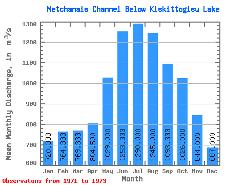
| Statistic | Jan | Feb | Mar | Apr | May | Jun | Jul | Aug | Sep | Oct | Nov | Dec | Annual |
|---|---|---|---|---|---|---|---|---|---|---|---|---|---|
| Mean | 720.33 | 764.33 | 769.33 | 804.50 | 1029.00 | 1253.33 | 1290.00 | 1245.00 | 1093.33 | 1026.00 | 844.00 | 687.00 | 939.08 |
| Standard Deviation | 104.08 | 165.35 | 157.56 | 111.02 | 199.40 | 5.77 | 155.56 | 190.92 | 127.41 | 118.79 | |||
| Min | 614.00 | 630.00 | 620.00 | 726.00 | 888.00 | 1250.00 | 1180.00 | 1110.00 | 1010.00 | 942.00 | 844.00 | 687.00 | 939.08 |
| Max | 822.00 | 949.00 | 934.00 | 883.00 | 1170.00 | 1260.00 | 1400.00 | 1380.00 | 1240.00 | 1110.00 | 844.00 | 687.00 | 939.08 |
| Coefficient of Variation | 0.14 | 0.22 | 0.20 | 0.14 | 0.19 | 0.01 | 0.12 | 0.15 | 0.12 | 0.12 |
| Year | Jan | Feb | Mar | Apr | May | Jun | Jul | Aug | Sep | Oct | Nov | Dec | Annual | 1971 | 822.00 | 949.00 | 934.00 | 1260.00 | 1030.00 | 1972 | 725.00 | 714.00 | 754.00 | 883.00 | 1170.00 | 1250.00 | 1180.00 | 1110.00 | 1010.00 | 942.00 | 844.00 | 687.00 | 939.08 | 1973 | 614.00 | 630.00 | 620.00 | 726.00 | 888.00 | 1250.00 | 1400.00 | 1380.00 | 1240.00 | 1110.00 |
|---|
 Return to R-Arctic Net Home Page