|
|
|||||||||||||||||
| Point ID: 3082 | Downloads | Plots | Site Data | Code: 05RD001 |
|
|
|||||||||||||||||
| Download | |
|---|---|
| Site Descriptor Information | Site Time Series Data |
| Link to all available data | |
|
|
| View: | Statistics | Time Series |
| Units: | mm |
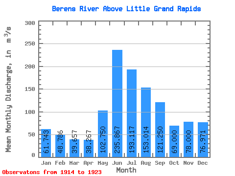
| Statistic | Jan | Feb | Mar | Apr | May | Jun | Jul | Aug | Sep | Oct | Nov | Dec | Annual |
|---|---|---|---|---|---|---|---|---|---|---|---|---|---|
| Mean | 61.74 | 48.79 | 39.66 | 38.27 | 102.75 | 235.87 | 193.12 | 153.01 | 121.25 | 69.00 | 78.00 | 76.97 | 104.17 |
| Standard Deviation | 16.78 | 9.29 | 5.70 | 7.97 | 43.74 | 107.11 | 91.63 | 58.07 | 75.26 | 28.94 | 47.51 | 33.77 | 22.79 |
| Min | 47.60 | 40.60 | 34.50 | 30.90 | 34.50 | 41.20 | 68.70 | 68.10 | 46.60 | 37.70 | 36.50 | 50.50 | 74.17 |
| Max | 96.00 | 68.60 | 51.50 | 53.80 | 171.00 | 368.00 | 319.00 | 263.00 | 255.00 | 123.00 | 178.00 | 145.00 | 135.83 |
| Coefficient of Variation | 0.27 | 0.19 | 0.14 | 0.21 | 0.43 | 0.45 | 0.47 | 0.38 | 0.62 | 0.42 | 0.61 | 0.44 | 0.22 |
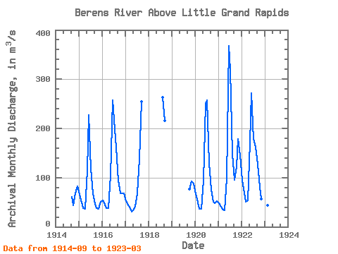
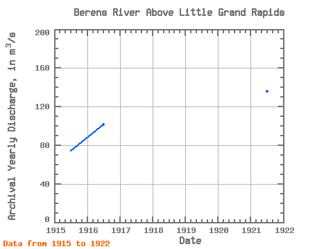
| Year | Jan | Feb | Mar | Apr | May | Jun | Jul | Aug | Sep | Oct | Nov | Dec | Annual | 1914 | 60.80 | 44.40 | 67.90 | 82.80 | 1915 | 65.60 | 49.30 | 38.60 | 36.50 | 115.00 | 227.00 | 118.00 | 68.10 | 46.60 | 37.70 | 36.50 | 51.10 | 74.17 | 1916 | 53.90 | 45.80 | 38.70 | 37.70 | 104.00 | 258.00 | 217.00 | 162.00 | 94.10 | 68.70 | 67.50 | 68.40 | 101.32 | 1917 | 52.90 | 44.20 | 41.50 | 30.90 | 34.50 | 41.20 | 68.70 | 139.00 | 255.00 | 1918 | 263.00 | 216.00 | 1919 | 77.10 | 92.40 | 88.60 | 1920 | 66.30 | 49.50 | 37.20 | 36.30 | 94.20 | 250.00 | 258.00 | 130.00 | 75.40 | 51.20 | 47.70 | 52.40 | 95.68 | 1921 | 47.60 | 40.60 | 34.50 | 34.40 | 97.80 | 368.00 | 319.00 | 147.00 | 95.10 | 123.00 | 178.00 | 145.00 | 135.83 | 1922 | 96.00 | 68.60 | 51.50 | 53.80 | 171.00 | 271.00 | 178.00 | 162.00 | 127.00 | 80.90 | 56.00 | 50.50 | 113.86 | 1923 | 49.90 | 43.50 | 35.60 |
|---|
 Return to R-Arctic Net Home Page