|
|
|||||||||||||||||
| Point ID: 3075 | Downloads | Plots | Site Data | Code: 05PH001 |
|
|
|||||||||||||||||
| Download | |
|---|---|
| Site Descriptor Information | Site Time Series Data |
| Link to all available data | |
| View: | Time Series | All |
| Units: | m3/s |
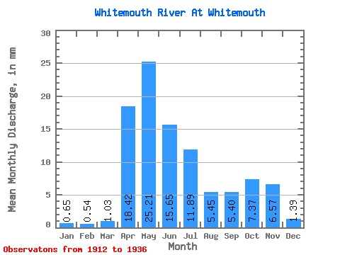
| Statistic | Jan | Feb | Mar | Apr | May | Jun | Jul | Aug | Sep | Oct | Nov | Dec | Annual |
|---|---|---|---|---|---|---|---|---|---|---|---|---|---|
| Mean | 0.65 | 0.55 | 1.03 | 18.42 | 25.20 | 15.65 | 11.89 | 5.45 | 5.40 | 7.37 | 6.57 | 1.39 | 96.02 |
| Standard Deviation | 0.56 | 0.64 | 1.11 | 11.78 | 19.00 | 13.36 | 12.11 | 5.37 | 7.33 | 8.13 | 5.16 | 0.69 | 34.77 |
| Min | 0.15 | 0.11 | 0.32 | 5.18 | 6.26 | 2.17 | 0.45 | 0.20 | 0.37 | 0.47 | 1.06 | 0.38 | 49.70 |
| Max | 2.06 | 2.21 | 3.63 | 39.98 | 86.89 | 64.11 | 47.01 | 18.02 | 33.85 | 32.91 | 19.51 | 2.72 | 146.75 |
| Coefficient of Variation | 0.87 | 1.17 | 1.08 | 0.64 | 0.75 | 0.85 | 1.02 | 0.98 | 1.36 | 1.10 | 0.79 | 0.50 | 0.36 |
 Return to R-Arctic Net Home Page