|
|
|||||||||||||||||
| Point ID: 3063 | Downloads | Plots | Site Data | Code: 05PF015 |
|
|
|||||||||||||||||
| Download | |
|---|---|
| Site Descriptor Information | Site Time Series Data |
| Link to all available data | |
|
|
| View: | Statistics | Time Series |
| Units: | mm |
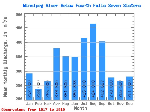
| Statistic | Jan | Feb | Mar | Apr | May | Jun | Jul | Aug | Sep | Oct | Nov | Dec | Annual |
|---|---|---|---|---|---|---|---|---|---|---|---|---|---|
| Mean | 292.00 | 238.00 | 265.00 | 379.50 | 351.50 | 350.33 | 415.00 | 464.00 | 402.67 | 278.00 | 266.50 | 281.00 | |
| Standard Deviation | 8.48 | 26.87 | 152.03 | 92.63 | 26.69 | 257.82 | 320.66 | 217.66 | 5.66 | 4.95 | |||
| Min | 292.00 | 232.00 | 246.00 | 272.00 | 286.00 | 322.00 | 203.00 | 253.00 | 276.00 | 274.00 | 263.00 | 281.00 | |
| Max | 292.00 | 244.00 | 284.00 | 487.00 | 417.00 | 375.00 | 702.00 | 833.00 | 654.00 | 282.00 | 270.00 | 281.00 | |
| Coefficient of Variation | 0.04 | 0.10 | 0.40 | 0.26 | 0.08 | 0.62 | 0.69 | 0.54 | 0.02 | 0.02 |
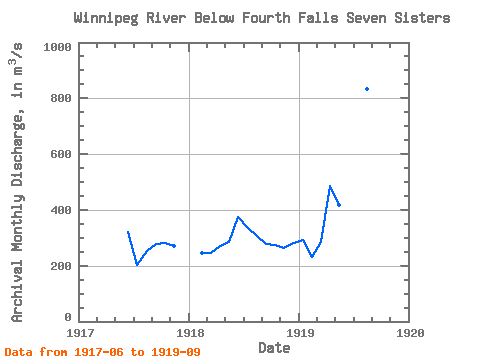
| Year | Jan | Feb | Mar | Apr | May | Jun | Jul | Aug | Sep | Oct | Nov | Dec | Annual | 1917 | 322.00 | 203.00 | 253.00 | 278.00 | 282.00 | 270.00 | 1918 | 244.00 | 246.00 | 272.00 | 286.00 | 375.00 | 340.00 | 306.00 | 276.00 | 274.00 | 263.00 | 281.00 | 1919 | 292.00 | 232.00 | 284.00 | 487.00 | 417.00 | 354.00 | 702.00 | 833.00 | 654.00 |
|---|
 Return to R-Arctic Net Home Page