|
|
|||||||||||||||||
| Point ID: 3047 | Downloads | Plots | Site Data | Code: 05OH007 |
|
|
|||||||||||||||||
| Download | |
|---|---|
| Site Descriptor Information | Site Time Series Data |
| Link to all available data | |
| View: | Time Series | All |
| Units: | m3/s |
| Statistic | Jan | Feb | Mar | Apr | May | Jun | Jul | Aug | Sep | Oct | Nov | Dec | Annual |
|---|---|---|---|---|---|---|---|---|---|---|---|---|---|
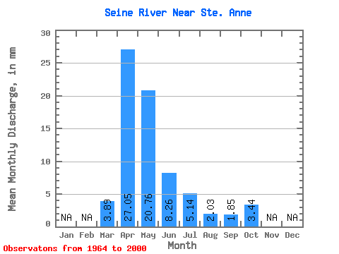
| Mean | 3.88 | 27.05 | 20.76 | 8.26 | 5.14 | 2.03 | 1.84 | 3.44 | |||||
| Standard Deviation | 6.22 | 29.11 | 21.61 | 7.74 | 8.52 | 5.70 | 2.86 | 3.76 | |||||
| Min | 0.00 | 2.27 | 2.09 | 0.60 | 0.10 | 0.03 | 0.00 | 0.08 | |||||
| Max | 30.99 | 135.55 | 76.65 | 28.44 | 46.79 | 33.12 | 13.74 | 17.08 | |||||
| Coefficient of Variation | 1.60 | 1.08 | 1.04 | 0.94 | 1.66 | 2.81 | 1.55 | 1.09 |
 Return to R-Arctic Net Home Page