|
|
|||||||||||||||||
| Point ID: 3042 | Downloads | Plots | Site Data | Code: 05OG009 |
|
|
|||||||||||||||||
| Download | |
|---|---|
| Site Descriptor Information | Site Time Series Data |
| Link to all available data | |
| View: | Time Series | All |
| Units: | m3/s |
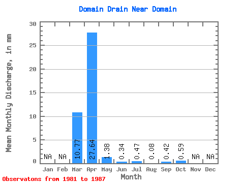
| Statistic | Jan | Feb | Mar | Apr | May | Jun | Jul | Aug | Sep | Oct | Nov | Dec | Annual |
|---|---|---|---|---|---|---|---|---|---|---|---|---|---|
| Mean | 10.76 | 27.65 | 1.36 | 0.36 | 0.46 | 0.09 | 0.40 | 0.61 | |||||
| Standard Deviation | 13.69 | 29.95 | 2.34 | 0.51 | 0.72 | 0.13 | 1.07 | 1.52 | |||||
| Min | 0.95 | 0.65 | 0.00 | 0.00 | 0.00 | 0.00 | 0.00 | 0.00 | |||||
| Max | 39.84 | 71.77 | 6.19 | 1.15 | 1.93 | 0.35 | 2.83 | 4.06 | |||||
| Coefficient of Variation | 1.27 | 1.08 | 1.72 | 1.42 | 1.55 | 1.42 | 2.65 | 2.51 |
 Return to R-Arctic Net Home Page