|
|
|||||||||||||||||
| Point ID: 3032 | Downloads | Plots | Site Data | Code: 05OF020 |
|
|
|||||||||||||||||
| Download | |
|---|---|
| Site Descriptor Information | Site Time Series Data |
| Link to all available data | |
| View: | Time Series | All |
| Units: | m3/s |
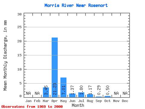
| Statistic | Jan | Feb | Mar | Apr | May | Jun | Jul | Aug | Sep | Oct | Nov | Dec | Annual |
|---|---|---|---|---|---|---|---|---|---|---|---|---|---|
| Mean | 3.44 | 21.23 | 7.00 | 1.37 | 1.80 | 1.17 | 0.29 | 0.50 | |||||
| Standard Deviation | 6.55 | 18.51 | 13.35 | 1.22 | 3.98 | 3.95 | 0.41 | 1.48 | |||||
| Min | 0.00 | 0.45 | 0.33 | 0.02 | 0.00 | 0.00 | 0.00 | 0.00 | |||||
| Max | 30.32 | 70.79 | 50.02 | 3.90 | 16.17 | 20.46 | 1.66 | 7.79 | |||||
| Coefficient of Variation | 1.90 | 0.87 | 1.91 | 0.89 | 2.21 | 3.37 | 1.39 | 2.97 |
 Return to R-Arctic Net Home Page