|
|
|||||||||||||||||
| Point ID: 3030 | Downloads | Plots | Site Data | Code: 05OF018 |
|
|
|||||||||||||||||
| Download | |
|---|---|
| Site Descriptor Information | Site Time Series Data |
| Link to all available data | |
| View: | Time Series | All |
| Units: | m3/s |
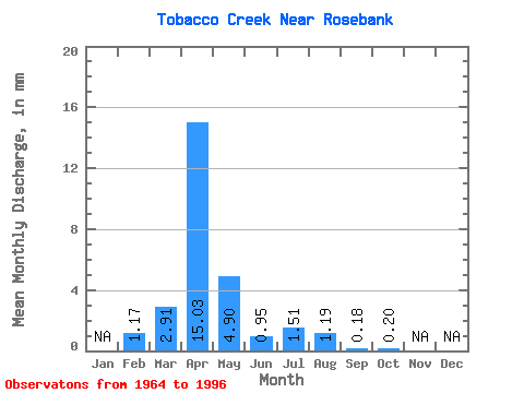
| Statistic | Jan | Feb | Mar | Apr | May | Jun | Jul | Aug | Sep | Oct | Nov | Dec | Annual |
|---|---|---|---|---|---|---|---|---|---|---|---|---|---|
| Mean | 1.18 | 2.91 | 15.04 | 4.89 | 0.95 | 1.50 | 1.18 | 0.18 | 0.20 | ||||
| Standard Deviation | 4.70 | 18.65 | 8.35 | 1.41 | 3.42 | 4.06 | 0.57 | 0.65 | |||||
| Min | 1.18 | 0.00 | 0.03 | 0.00 | 0.00 | 0.00 | 0.00 | 0.00 | 0.00 | ||||
| Max | 1.18 | 20.16 | 64.80 | 37.25 | 5.02 | 16.01 | 20.16 | 2.84 | 3.09 | ||||
| Coefficient of Variation | 1.61 | 1.24 | 1.71 | 1.48 | 2.27 | 3.45 | 3.17 | 3.23 |
 Return to R-Arctic Net Home Page