MACKENZIE RIVER NEAR FORT PROVIDENCE
Mackenzie
Point ID:
3614
Downloads
|
Plots
|
Site Data
Code:
10FB001
Latitude:
61.26°
Distance to Outlet:
N/A
Longitude:
-117.54°
Yearly Min:
1961
X EASE-Grid:
-2804114.00
Yearly Max:
1997
Y EASE-Grid:
1462218.00
Number of Years:
21
Drainage Area:
980000.00 km
2
Percentage of Coverage:
57%
Drainage Area Effective:
980000.00 km
2
Percentage of Coverage by Month:
40%
Source:
Hydat
Notes:
Gauge Altitude:
N/A
Field Definitions
Download
Site Descriptor Information
Site Time Series Data
Link to all available data
Site Data:
View:
Statistics
Time Series
All
Units:
mm
m
3
/s
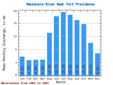
Summary Statistics
Statistic
Jan
Feb
Mar
Apr
May
Jun
Jul
Aug
Sep
Oct
Nov
Dec
Annual
Unable to open file ./Points/Stats3.614_mm.txtfor reading!