|
|
|||||||||||||||||
| Point ID: 2990 | Downloads | Plots | Site Data | Code: 05OC023 |
|
|
|||||||||||||||||
| Download | |
|---|---|
| Site Descriptor Information | Site Time Series Data |
| Link to all available data | |
| View: | Time Series | All |
| Units: | m3/s |
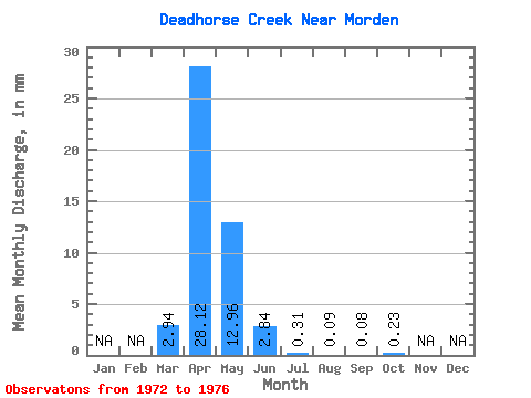
| Statistic | Jan | Feb | Mar | Apr | May | Jun | Jul | Aug | Sep | Oct | Nov | Dec | Annual |
|---|---|---|---|---|---|---|---|---|---|---|---|---|---|
| Mean | 2.94 | 28.12 | 12.96 | 2.85 | 0.32 | 0.08 | 0.08 | 0.23 | |||||
| Standard Deviation | 6.39 | 31.82 | 23.40 | 4.21 | 0.50 | 0.18 | 0.18 | 0.50 | |||||
| Min | 0.00 | 0.10 | 0.12 | 0.05 | 0.02 | 0.00 | 0.00 | 0.00 | |||||
| Max | 14.36 | 80.28 | 54.60 | 9.74 | 1.18 | 0.40 | 0.40 | 1.13 | |||||
| Coefficient of Variation | 2.17 | 1.13 | 1.81 | 1.48 | 1.59 | 2.12 | 2.24 | 2.15 |
 Return to R-Arctic Net Home Page