|
|
| Point ID: 2990 | Downloads | Plots | Site Data | Code: 05OC023 |
|
| Download | |
|---|---|
| Site Descriptor Information | Site Time Series Data |
| Link to all available data | |
|
|
|
| View: | Statistics | All |
| Units: | m3/s |
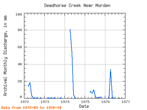
| Year | Jan | Feb | Mar | Apr | May | Jun | Jul | Aug | Sep | Oct | Nov | Dec | Annual | 1972 | 14.36 | 18.51 | 3.51 | 0.12 | 0.33 | 0.02 | 0.00 | 0.02 | 1973 | 0.17 | 0.10 | 0.12 | 0.05 | 0.02 | 0.00 | 0.00 | 0.02 | 1974 | 0.00 | 80.28 | 54.60 | 4.06 | 0.02 | 0.00 | 0.00 | 0.00 | 1975 | 0.00 | 7.73 | 5.96 | 9.74 | 1.18 | 0.40 | 0.40 | 1.13 | 1976 | 0.16 | 34.00 | 0.59 | 0.29 | 0.04 | 0.00 | 0.00 | 0.00 |
|---|
 Return to R-Arctic Net Home Page