|
|
|||||||||||||||||
| Point ID: 2951 | Downloads | Plots | Site Data | Other Close Sites | Code: 05NG025 |
|
|
|||||||||||||||||
| Download | |
|---|---|
| Site Descriptor Information | Site Time Series Data |
| Link to all available data | |

|
|
| View: | Statistics | Time Series |
| Units: | mm |
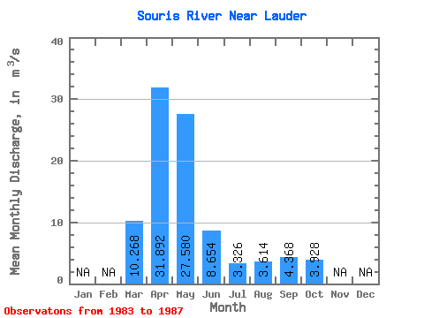
| Statistic | Jan | Feb | Mar | Apr | May | Jun | Jul | Aug | Sep | Oct | Nov | Dec | Annual |
|---|---|---|---|---|---|---|---|---|---|---|---|---|---|
| Mean | 10.27 | 31.89 | 27.58 | 8.65 | 3.33 | 3.61 | 4.37 | 3.93 | |||||
| Standard Deviation | 5.19 | 29.60 | 16.77 | 3.89 | 1.96 | 1.77 | 4.50 | 1.79 | |||||
| Min | 3.56 | 4.46 | 14.90 | 4.68 | 1.22 | 2.09 | 1.40 | 1.90 | |||||
| Max | 17.50 | 73.40 | 57.00 | 14.60 | 6.34 | 6.18 | 12.20 | 5.72 | |||||
| Coefficient of Variation | 0.51 | 0.93 | 0.61 | 0.45 | 0.59 | 0.49 | 1.03 | 0.46 |
| Year | Jan | Feb | Mar | Apr | May | Jun | Jul | Aug | Sep | Oct | Nov | Dec | Annual | 1983 | 17.50 | 73.40 | 57.00 | 9.33 | 6.34 | 4.70 | 12.20 | 5.72 | 1984 | 3.56 | 4.46 | 22.30 | 14.60 | 3.34 | 2.23 | 1.41 | 2.12 | 1985 | 12.70 | 13.50 | 14.90 | 8.98 | 1.22 | 2.87 | 3.69 | 4.70 | 1986 | 9.19 | 15.60 | 23.40 | 5.68 | 2.01 | 2.09 | 1.40 | 5.20 | 1987 | 8.39 | 52.50 | 20.30 | 4.68 | 3.72 | 6.18 | 3.14 | 1.90 |
|---|
| Other Close Sites | ||||||
|---|---|---|---|---|---|---|
| PointID | Latitude | Longitude | Drainage Area | Source | Name | |
| 2927 | "SOURIS RIVER AT MELITA" | 49.26 | 844036 | Hydat | ||
| 2932 | "SOURIS RIVER NEAR MELITA" | 49.17 | 850390 | Hydat | ||
| 2934 | "SOURIS RIVER NEAR WESTHOPE" | 48.99 | 847860 | Hydat | ||
| 2937 | "SOURIS RIVER NEAR COULTER" | 49.09 | 845882 | Hydat | ||
 Return to R-Arctic Net Home Page