|
|
|||||||||||||||||
| Point ID: 2931 | Downloads | Plots | Site Data | Code: 05NF008 |
|
|
|||||||||||||||||
| Download | |
|---|---|
| Site Descriptor Information | Site Time Series Data |
| Link to all available data | |
| View: | Time Series | All |
| Units: | m3/s |
| Statistic | Jan | Feb | Mar | Apr | May | Jun | Jul | Aug | Sep | Oct | Nov | Dec | Annual |
|---|---|---|---|---|---|---|---|---|---|---|---|---|---|
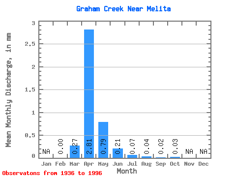
| Mean | 0.00 | 0.27 | 2.81 | 0.79 | 0.21 | 0.07 | 0.04 | 0.02 | 0.03 | ||||
| Standard Deviation | 0.60 | 7.30 | 1.65 | 0.34 | 0.16 | 0.19 | 0.11 | 0.14 | |||||
| Min | 0.00 | 0.00 | 0.00 | 0.00 | 0.00 | 0.00 | 0.00 | 0.00 | 0.00 | ||||
| Max | 0.00 | 2.60 | 51.13 | 7.52 | 1.94 | 0.73 | 1.32 | 0.64 | 1.00 | ||||
| Coefficient of Variation | 2.21 | 2.60 | 2.09 | 1.64 | 2.30 | 4.68 | 4.59 | 5.38 |
 Return to R-Arctic Net Home Page