|
|
|||||||||||||||||
| Point ID: 2916 | Downloads | Plots | Site Data | Other Close Sites | Code: 05MH013 |
|
|
|||||||||||||||||
| Download | |
|---|---|
| Site Descriptor Information | Site Time Series Data |
| Link to all available data | |
|
|
| View: | Statistics | Time Series |
| Units: | mm |
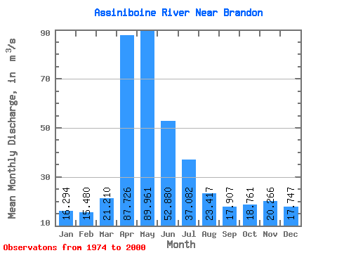
| Statistic | Jan | Feb | Mar | Apr | May | Jun | Jul | Aug | Sep | Oct | Nov | Dec | Annual |
|---|---|---|---|---|---|---|---|---|---|---|---|---|---|
| Mean | 16.29 | 15.48 | 21.21 | 87.73 | 89.96 | 52.88 | 37.08 | 23.42 | 17.91 | 18.76 | 20.27 | 17.75 | 34.89 |
| Standard Deviation | 6.16 | 5.91 | 9.83 | 75.37 | 104.69 | 50.84 | 29.73 | 18.80 | 14.65 | 11.80 | 8.39 | 6.52 | 23.55 |
| Min | 4.71 | 5.34 | 7.39 | 13.50 | 6.16 | 6.11 | 4.20 | 3.72 | 4.44 | 3.62 | 5.70 | 4.96 | 7.48 |
| Max | 30.20 | 29.60 | 43.70 | 335.00 | 472.00 | 177.00 | 96.00 | 57.10 | 63.30 | 59.50 | 48.10 | 33.30 | 93.83 |
| Coefficient of Variation | 0.38 | 0.38 | 0.46 | 0.86 | 1.16 | 0.96 | 0.80 | 0.80 | 0.82 | 0.63 | 0.41 | 0.37 | 0.68 |
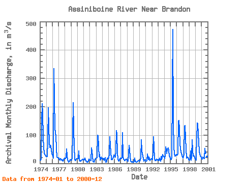
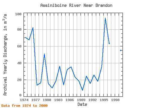
| Year | Jan | Feb | Mar | Apr | May | Jun | Jul | Aug | Sep | Oct | Nov | Dec | Annual | 1974 | 12.40 | 12.40 | 17.30 | 147.00 | 210.00 | 177.00 | 91.60 | 54.20 | 36.00 | 31.90 | 28.90 | 26.80 | 70.46 | 1975 | 25.00 | 24.60 | 23.80 | 78.70 | 196.00 | 126.00 | 75.60 | 57.10 | 63.30 | 59.50 | 48.10 | 33.30 | 67.58 | 1976 | 28.90 | 27.30 | 18.20 | 335.00 | 227.00 | 122.00 | 96.00 | 52.80 | 22.30 | 21.20 | 20.20 | 17.70 | 82.38 | 1977 | 18.00 | 13.70 | 11.70 | 16.20 | 14.50 | 11.00 | 12.60 | 9.91 | 8.75 | 12.50 | 15.70 | 18.60 | 13.60 | 1978 | 16.90 | 17.20 | 20.50 | 50.60 | 28.30 | 11.80 | 8.67 | 4.11 | 5.68 | 7.39 | 13.20 | 11.30 | 16.30 | 1979 | 11.00 | 11.00 | 18.70 | 106.00 | 214.00 | 120.00 | 60.00 | 14.30 | 9.51 | 11.10 | 14.80 | 17.80 | 50.68 | 1980 | 17.90 | 17.10 | 17.20 | 43.60 | 13.20 | 7.91 | 8.30 | 8.76 | 10.80 | 11.30 | 14.50 | 12.90 | 15.29 | 1981 | 11.80 | 12.80 | 18.90 | 13.50 | 8.39 | 8.64 | 4.98 | 3.72 | 4.45 | 10.20 | 14.80 | 12.50 | 10.39 | 1982 | 11.40 | 11.70 | 9.99 | 55.20 | 43.00 | 26.70 | 6.60 | 6.40 | 4.44 | 9.96 | 15.10 | 16.30 | 18.07 | 1983 | 19.30 | 18.40 | 20.20 | 98.70 | 97.70 | 58.60 | 24.90 | 30.60 | 11.10 | 13.40 | 21.90 | 16.50 | 35.94 | 1984 | 18.80 | 18.20 | 14.20 | 17.30 | 10.60 | 12.90 | 21.10 | 5.16 | 4.63 | 8.17 | 18.00 | 18.10 | 13.93 | 1985 | 17.80 | 18.10 | 34.90 | 93.40 | 61.20 | 42.10 | 13.50 | 13.80 | 17.50 | 19.90 | 29.40 | 25.30 | 32.24 | 1986 | 22.30 | 21.60 | 43.70 | 116.00 | 101.00 | 38.30 | 14.40 | 10.20 | 7.73 | 12.40 | 17.20 | 18.10 | 35.24 | 1987 | 17.50 | 16.70 | 19.80 | 108.00 | 24.30 | 14.40 | 12.80 | 9.60 | 9.62 | 13.00 | 15.50 | 14.70 | 22.99 | 1988 | 10.10 | 7.42 | 7.39 | 34.30 | 64.50 | 48.30 | 23.10 | 8.14 | 6.10 | 3.62 | 5.70 | 4.96 | 18.64 | 1989 | 4.71 | 5.34 | 7.61 | 19.20 | 6.16 | 6.11 | 4.20 | 3.95 | 5.39 | 7.72 | 9.99 | 9.40 | 7.48 | 1990 | 8.59 | 11.30 | 21.00 | 83.20 | 44.60 | 32.90 | 26.20 | 17.80 | 8.29 | 11.50 | 13.90 | 10.30 | 24.13 | 1991 | 8.45 | 8.69 | 9.77 | 33.70 | 20.50 | 13.40 | 22.00 | 15.90 | 9.41 | 14.30 | 15.40 | 16.20 | 15.64 | 1992 | 15.70 | 13.30 | 41.00 | 94.00 | 58.40 | 17.20 | 9.67 | 9.80 | 9.10 | 14.90 | 13.30 | 11.30 | 25.64 | 1993 | 13.50 | 10.60 | 12.00 | 19.70 | 11.20 | 8.70 | 24.40 | 13.40 | 20.50 | 30.60 | 26.20 | 24.60 | 17.95 | 1994 | 25.00 | 17.20 | 27.00 | 57.80 | 48.60 | 34.90 | 49.20 | 54.90 | 44.10 | 25.90 | 24.60 | 16.20 | 35.45 | 1995 | 14.80 | 12.70 | 22.80 | 261.00 | 472.00 | 139.00 | 60.20 | 33.40 | 25.20 | 26.20 | 27.20 | 31.50 | 93.83 | 1996 | 30.20 | 29.60 | 34.10 | 149.00 | 151.00 | 120.00 | 68.20 | 52.20 | 39.40 | 35.80 | 28.20 | 22.50 | 63.35 | 1997 | 18.90 | 23.10 | 35.60 | 132.00 | 134.00 | 87.90 | 50.70 | 19.10 | 20.40 | 23.20 | 20.10 | 13.90 | 48.24 | 1998 | 12.40 | 10.90 | 14.80 | 43.50 | 11.20 | 22.00 | 84.00 | 43.50 | 25.10 | 27.30 | 26.60 | 18.80 | 28.34 | 1999 | 13.50 | 11.50 | 28.90 | 142.00 | 141.00 | 103.00 | 74.90 | 41.90 | 33.50 | 26.50 | 24.50 | 19.80 | 55.08 | 2000 | 15.10 | 15.50 | 21.60 | 20.00 | 16.60 | 17.00 | 53.40 | 37.60 | 21.20 | 17.10 | 24.20 | 19.80 | 23.26 |
|---|
| Other Close Sites | ||||||
|---|---|---|---|---|---|---|
| PointID | Latitude | Longitude | Drainage Area | Source | Name | |
| 2908 | "ASSINIBOINE RIVER AT BRANDON" | 49.85 | 754247 | Hydat | ||
 Return to R-Arctic Net Home Page