|
|
|||||||||||||||||
| Point ID: 2906 | Downloads | Plots | Site Data | Code: 05MG011 |
|
|
|||||||||||||||||
| Download | |
|---|---|
| Site Descriptor Information | Site Time Series Data |
| Link to all available data | |
|
|
| View: | Statistics | Time Series |
| Units: | mm |
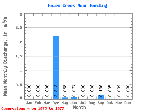
| Statistic | Jan | Feb | Mar | Apr | May | Jun | Jul | Aug | Sep | Oct | Nov | Dec | Annual |
|---|---|---|---|---|---|---|---|---|---|---|---|---|---|
| Mean | 0.00 | 0.00 | 0.01 | 2.21 | 0.06 | 0.08 | 0.01 | 0.01 | 0.14 | 0.01 | 0.00 | 0.00 | 0.21 |
| Standard Deviation | 0.00 | 0.00 | 0.01 | 1.96 | 0.07 | 0.10 | 0.01 | 0.01 | 0.23 | 0.01 | 0.00 | 0.00 | 0.18 |
| Min | 0.00 | 0.00 | 0.00 | 0.01 | 0.01 | 0.00 | 0.00 | 0.00 | 0.00 | 0.00 | 0.00 | 0.00 | 0.01 |
| Max | 0.00 | 0.00 | 0.02 | 3.80 | 0.14 | 0.19 | 0.01 | 0.02 | 0.41 | 0.01 | 0.01 | 0.00 | 0.34 |
| Coefficient of Variation | 1.73 | 0.89 | 1.24 | 1.27 | 1.32 | 1.41 | 1.72 | 1.57 | 0.96 | 1.73 | 0.85 |
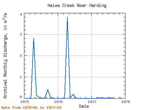
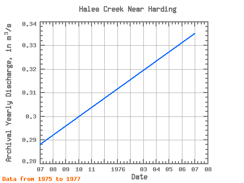
| Year | Jan | Feb | Mar | Apr | May | Jun | Jul | Aug | Sep | Oct | Nov | Dec | Annual | 1975 | 0.00 | 0.00 | 0.00 | 2.82 | 0.14 | 0.04 | 0.00 | 0.02 | 0.41 | 0.01 | 0.01 | 0.00 | 0.29 | 1976 | 0.00 | 0.00 | 0.00 | 3.80 | 0.03 | 0.19 | 0.00 | 0.00 | 0.00 | 0.00 | 0.00 | 0.00 | 0.34 | 1977 | 0.00 | 0.00 | 0.02 | 0.01 | 0.01 | 0.00 | 0.01 | 0.00 | 0.00 | 0.00 | 0.00 | 0.00 | 0.01 |
|---|
 Return to R-Arctic Net Home Page