|
|
|||||||||||||||||
| Point ID: 2896 | Downloads | Plots | Site Data | Code: 05MF022 |
|
|
|||||||||||||||||
| Download | |
|---|---|
| Site Descriptor Information | Site Time Series Data |
| Link to all available data | |
|
|
| View: | Statistics | Time Series |
| Units: | mm |
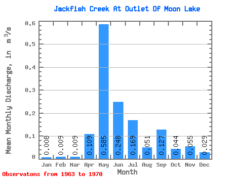
| Statistic | Jan | Feb | Mar | Apr | May | Jun | Jul | Aug | Sep | Oct | Nov | Dec | Annual |
|---|---|---|---|---|---|---|---|---|---|---|---|---|---|
| Mean | 0.01 | 0.01 | 0.01 | 0.11 | 0.58 | 0.25 | 0.17 | 0.05 | 0.13 | 0.04 | 0.06 | 0.03 | 0.13 |
| Standard Deviation | 0.01 | 0.01 | 0.01 | 0.13 | 0.31 | 0.14 | 0.27 | 0.07 | 0.22 | 0.07 | 0.09 | 0.04 | 0.05 |
| Min | 0.00 | 0.00 | 0.00 | 0.00 | 0.18 | 0.00 | 0.00 | 0.00 | 0.00 | 0.00 | 0.00 | 0.00 | 0.06 |
| Max | 0.03 | 0.03 | 0.03 | 0.31 | 1.19 | 0.46 | 0.78 | 0.19 | 0.53 | 0.19 | 0.27 | 0.11 | 0.18 |
| Coefficient of Variation | 1.48 | 1.37 | 1.37 | 1.15 | 0.54 | 0.56 | 1.57 | 1.30 | 1.70 | 1.49 | 1.63 | 1.32 | 0.36 |
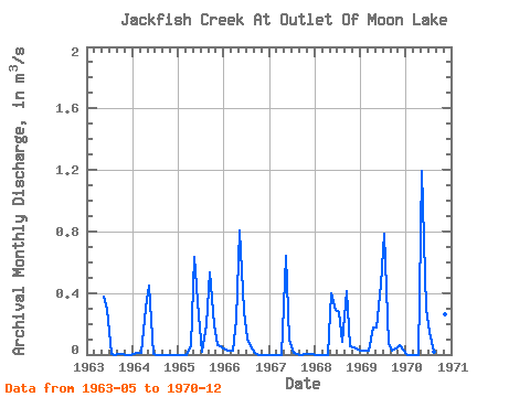
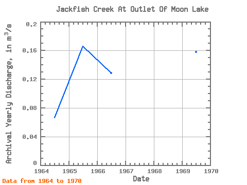
| Year | Jan | Feb | Mar | Apr | May | Jun | Jul | Aug | Sep | Oct | Nov | Dec | Annual | 1963 | 0.38 | 0.30 | 0.00 | 0.00 | 0.00 | 0.00 | 0.00 | 0.00 | 1964 | 0.01 | 0.01 | 0.01 | 0.31 | 0.45 | 0.00 | 0.00 | 0.00 | 0.00 | 0.00 | 0.00 | 0.00 | 0.07 | 1965 | 0.00 | 0.00 | 0.00 | 0.06 | 0.64 | 0.25 | 0.02 | 0.19 | 0.53 | 0.19 | 0.06 | 0.05 | 0.17 | 1966 | 0.03 | 0.03 | 0.03 | 0.22 | 0.81 | 0.28 | 0.10 | 0.04 | 0.01 | 0.00 | 0.00 | 0.00 | 0.13 | 1967 | 0.00 | 0.00 | 0.00 | 0.00 | 0.64 | 0.10 | 0.01 | 0.00 | 0.00 | 0.00 | 0.01 | 0.01 | 0.06 | 1968 | 0.00 | 0.00 | 0.00 | 0.00 | 0.40 | 0.29 | 0.28 | 0.08 | 0.41 | 0.06 | 0.05 | 0.03 | 0.13 | 1969 | 0.02 | 0.03 | 0.03 | 0.18 | 0.18 | 0.46 | 0.78 | 0.07 | 0.03 | 0.04 | 0.06 | 0.03 | 0.16 | 1970 | 0.00 | 0.00 | 0.00 | 0.00 | 1.19 | 0.30 | 0.15 | 0.02 | 0.03 | 0.06 | 0.27 | 0.11 | 0.18 |
|---|
 Return to R-Arctic Net Home Page