|
|
|||||||||||||||||
| Point ID: 2814 | Downloads | Plots | Site Data | Other Close Sites | Code: 05LH005 |
|
|
|||||||||||||||||
| Download | |
|---|---|
| Site Descriptor Information | Site Time Series Data |
| Link to all available data | |
|
|
| View: | Statistics | Time Series |
| Units: | mm |
| Statistic | Jan | Feb | Mar | Apr | May | Jun | Jul | Aug | Sep | Oct | Nov | Dec | Annual |
|---|---|---|---|---|---|---|---|---|---|---|---|---|---|
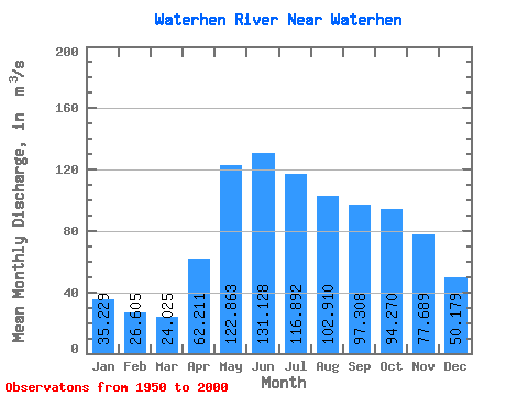
| Mean | 35.23 | 26.61 | 24.02 | 62.21 | 122.86 | 131.13 | 116.89 | 102.91 | 97.31 | 94.27 | 77.69 | 50.18 | 76.21 |
| Standard Deviation | 34.51 | 30.95 | 29.26 | 47.38 | 52.62 | 55.57 | 49.49 | 46.24 | 50.48 | 49.68 | 46.84 | 43.17 | 36.13 |
| Min | 0.04 | 0.00 | 0.00 | 2.35 | 26.60 | 26.10 | 13.70 | 12.80 | 11.20 | 11.20 | 7.62 | 0.55 | 11.11 |
| Max | 168.00 | 139.00 | 127.00 | 233.00 | 295.00 | 317.00 | 277.00 | 234.00 | 286.00 | 291.00 | 273.00 | 249.00 | 201.17 |
| Coefficient of Variation | 0.98 | 1.16 | 1.22 | 0.76 | 0.43 | 0.42 | 0.42 | 0.45 | 0.52 | 0.53 | 0.60 | 0.86 | 0.47 |
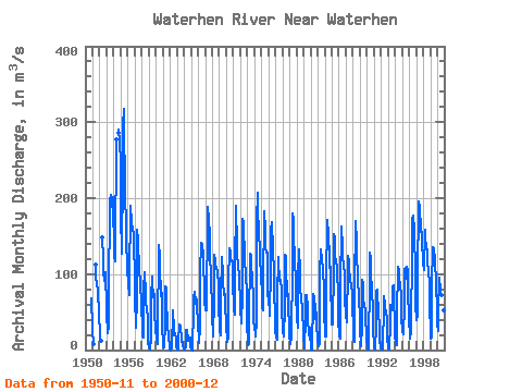
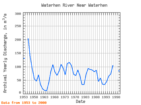
| Year | Jan | Feb | Mar | Apr | May | Jun | Jul | Aug | Sep | Oct | Nov | Dec | Annual | 1950 | 68.70 | 28.50 | 1951 | 19.60 | 14.00 | 8.29 | 113.00 | 99.50 | 83.30 | 80.50 | 73.30 | 51.40 | 42.60 | 1952 | 24.90 | 12.30 | 11.90 | 148.00 | 120.00 | 102.00 | 91.60 | 102.00 | 90.10 | 68.60 | 1953 | 42.10 | 27.50 | 22.00 | 31.80 | 116.00 | 150.00 | 200.00 | 189.00 | 204.00 | 198.00 | 202.00 | 179.00 | 130.12 | 1954 | 144.00 | 123.00 | 117.00 | 159.00 | 248.00 | 277.00 | 286.00 | 291.00 | 273.00 | 249.00 | 1955 | 168.00 | 139.00 | 127.00 | 233.00 | 295.00 | 317.00 | 277.00 | 234.00 | 193.00 | 176.00 | 149.00 | 106.00 | 201.17 | 1956 | 88.50 | 87.30 | 72.50 | 111.00 | 168.00 | 190.00 | 167.00 | 161.00 | 163.00 | 163.00 | 148.00 | 88.50 | 133.98 | 1957 | 60.70 | 38.70 | 28.70 | 68.10 | 159.00 | 146.00 | 132.00 | 116.00 | 103.00 | 93.10 | 90.80 | 57.60 | 91.14 | 1958 | 30.80 | 17.30 | 15.80 | 79.80 | 102.00 | 99.10 | 78.20 | 63.10 | 54.30 | 52.70 | 44.20 | 11.10 | 54.03 | 1959 | 3.88 | 0.41 | 0.06 | 16.00 | 67.50 | 96.50 | 88.00 | 71.40 | 69.80 | 73.60 | 44.30 | 32.10 | 46.96 | 1960 | 24.60 | 16.00 | 8.17 | 44.70 | 115.00 | 138.00 | 124.00 | 104.00 | 79.80 | 71.40 | 75.80 | 27.00 | 69.04 | 1961 | 12.40 | 3.04 | 3.79 | 35.10 | 84.50 | 82.50 | 61.50 | 39.50 | 28.40 | 21.90 | 19.10 | 3.40 | 32.93 | 1962 | 0.04 | 0.00 | 0.00 | 2.35 | 52.60 | 44.00 | 36.40 | 19.90 | 18.90 | 21.80 | 14.80 | 4.21 | 17.92 | 1963 | 0.20 | 0.01 | 0.17 | 11.50 | 34.00 | 32.10 | 27.40 | 15.80 | 11.20 | 11.20 | 7.62 | 0.55 | 12.64 | 1964 | 0.07 | 0.12 | 0.14 | 4.04 | 26.60 | 26.10 | 13.70 | 12.80 | 13.30 | 16.20 | 16.90 | 3.37 | 11.11 | 1965 | 0.08 | 0.03 | 0.00 | 4.65 | 51.50 | 69.00 | 76.60 | 62.40 | 60.30 | 66.70 | 55.40 | 39.00 | 40.47 | 1966 | 28.60 | 21.40 | 9.14 | 29.50 | 108.00 | 136.00 | 141.00 | 139.00 | 126.00 | 125.00 | 68.90 | 59.50 | 82.67 | 1967 | 58.20 | 52.90 | 52.10 | 82.60 | 153.00 | 188.00 | 172.00 | 151.00 | 115.00 | 108.00 | 92.00 | 55.60 | 106.70 | 1968 | 37.30 | 26.20 | 18.40 | 68.00 | 125.00 | 118.00 | 111.00 | 108.00 | 103.00 | 103.00 | 87.20 | 53.10 | 79.85 | 1969 | 33.40 | 25.10 | 19.80 | 70.00 | 123.00 | 122.00 | 100.00 | 88.90 | 72.10 | 73.50 | 55.30 | 37.50 | 68.38 | 1970 | 28.00 | 17.30 | 10.20 | 18.60 | 98.30 | 125.00 | 134.00 | 130.00 | 117.00 | 118.00 | 116.00 | 79.90 | 82.69 | 1971 | 66.50 | 53.80 | 47.00 | 107.00 | 190.00 | 176.00 | 150.00 | 129.00 | 110.00 | 117.00 | 92.40 | 64.40 | 108.59 | 1972 | 47.60 | 42.80 | 34.60 | 72.70 | 173.00 | 169.00 | 154.00 | 133.00 | 115.00 | 102.00 | 72.90 | 30.30 | 95.58 | 1973 | 15.30 | 6.53 | 7.50 | 54.60 | 105.00 | 127.00 | 124.00 | 106.00 | 99.40 | 95.60 | 68.00 | 40.90 | 70.82 | 1974 | 27.50 | 22.00 | 17.90 | 39.40 | 172.00 | 207.00 | 181.00 | 160.00 | 149.00 | 139.00 | 126.00 | 95.50 | 111.36 | 1975 | 74.60 | 56.80 | 51.70 | 91.40 | 174.00 | 183.00 | 157.00 | 135.00 | 129.00 | 129.00 | 128.00 | 76.70 | 115.52 | 1976 | 62.80 | 54.00 | 45.60 | 110.00 | 159.00 | 169.00 | 158.00 | 141.00 | 123.00 | 113.00 | 82.50 | 40.60 | 104.88 | 1977 | 26.40 | 16.40 | 14.30 | 68.10 | 122.00 | 113.00 | 96.80 | 91.60 | 91.60 | 92.80 | 77.60 | 47.60 | 71.52 | 1978 | 35.30 | 23.90 | 17.60 | 56.50 | 126.00 | 123.00 | 101.00 | 83.00 | 70.70 | 73.70 | 58.40 | 30.90 | 66.67 | 1979 | 17.60 | 9.85 | 7.45 | 17.30 | 110.00 | 180.00 | 171.00 | 146.00 | 125.00 | 120.00 | 88.10 | 64.70 | 88.08 | 1980 | 52.40 | 41.50 | 30.00 | 96.60 | 133.00 | 105.00 | 79.70 | 67.80 | 62.40 | 60.60 | 53.00 | 23.50 | 67.12 | 1981 | 19.60 | 2.83 | 8.06 | 38.10 | 71.80 | 72.40 | 56.80 | 39.70 | 23.20 | 18.70 | 29.50 | 21.70 | 33.53 | 1982 | 2.71 | 0.42 | 0.63 | 6.35 | 61.90 | 74.40 | 69.20 | 52.20 | 41.20 | 49.80 | 33.10 | 15.40 | 33.94 | 1983 | 12.80 | 7.46 | 5.12 | 8.77 | 102.00 | 131.00 | 133.00 | 120.00 | 107.00 | 100.00 | 86.80 | 46.70 | 71.72 | 1984 | 23.70 | 17.80 | 18.20 | 95.70 | 167.00 | 171.00 | 151.00 | 124.00 | 108.00 | 109.00 | 74.90 | 52.70 | 92.75 | 1985 | 34.00 | 33.40 | 36.30 | 106.00 | 152.00 | 149.00 | 125.00 | 116.00 | 111.00 | 107.00 | 70.60 | 33.90 | 89.52 | 1986 | 25.80 | 19.00 | 15.50 | 84.00 | 163.00 | 158.00 | 138.00 | 125.00 | 109.00 | 102.00 | 67.90 | 45.60 | 87.73 | 1987 | 45.20 | 36.10 | 37.50 | 108.00 | 124.00 | 117.00 | 103.00 | 97.20 | 90.00 | 88.50 | 73.10 | 58.30 | 81.49 | 1988 | 30.90 | 13.90 | 11.00 | 81.00 | 170.00 | 169.00 | 142.00 | 119.00 | 104.00 | 92.00 | 69.00 | 41.10 | 86.91 | 1989 | 22.00 | 10.80 | 4.81 | 32.20 | 92.30 | 87.70 | 70.20 | 56.10 | 58.70 | 53.30 | 44.70 | 15.80 | 45.72 | 1990 | 1.91 | 1.22 | 1.04 | 8.80 | 91.30 | 128.00 | 120.00 | 97.30 | 82.90 | 71.70 | 59.40 | 27.40 | 57.58 | 1991 | 4.39 | 0.90 | 0.64 | 32.90 | 77.20 | 78.90 | 72.40 | 54.00 | 43.30 | 34.50 | 11.70 | 3.22 | 34.50 | 1992 | 0.92 | 0.26 | 0.50 | 6.28 | 55.10 | 70.80 | 60.90 | 50.00 | 50.60 | 52.00 | 39.30 | 16.60 | 33.60 | 1993 | 2.06 | 0.69 | 2.21 | 33.40 | 59.40 | 51.90 | 53.50 | 65.40 | 82.20 | 85.90 | 59.30 | 43.80 | 44.98 | 1994 | 21.40 | 6.29 | 5.75 | 45.80 | 110.00 | 109.00 | 106.00 | 95.40 | 85.60 | 80.80 | 74.60 | 39.70 | 65.03 | 1995 | 28.90 | 23.30 | 21.40 | 57.50 | 105.00 | 108.00 | 93.30 | 100.00 | 110.00 | 106.00 | 73.20 | 44.60 | 72.60 | 1996 | 37.90 | 21.40 | 15.30 | 25.00 | 135.00 | 171.00 | 177.00 | 176.00 | 158.00 | 148.00 | 110.00 | 56.90 | 102.62 | 1997 | 41.90 | 39.70 | 45.70 | 94.00 | 195.00 | 187.00 | 182.00 | 165.00 | 155.00 | 156.00 | 136.00 | 125.00 | 126.86 | 1998 | 114.00 | 106.00 | 105.00 | 159.00 | 148.00 | 134.00 | 132.00 | 117.00 | 104.00 | 101.00 | 89.30 | 56.20 | 113.79 | 1999 | 26.70 | 14.90 | 16.80 | 85.20 | 134.00 | 136.00 | 134.00 | 118.00 | 109.00 | 95.60 | 89.40 | 49.90 | 84.12 | 2000 | 33.30 | 24.70 | 51.00 | 94.80 | 92.40 | 83.00 | 76.60 | 71.80 | 67.40 | 59.60 | 52.90 | 23.40 | 60.91 |
|---|
| Other Close Sites | ||||||
|---|---|---|---|---|---|---|
| PointID | Latitude | Longitude | Drainage Area | Source | Name | |
| 2812 | "WATERHEN RIVER AT BERNARDIN'S FARM" | 51.81 | 690155 | Hydat | ||
| 2813 | "WATERHEN RIVER AT MCCREERY'S FARM" | 51.83 | 691241 | Hydat | ||
 Return to R-Arctic Net Home Page