|
|
|||||||||||||||||
| Point ID: 280 | Downloads | Plots | Site Data | Code: 05BG010 |
|
|
|||||||||||||||||
| Download | |
|---|---|
| Site Descriptor Information | Site Time Series Data |
| Link to all available data | |
| View: | Time Series | All |
| Units: | m3/s |
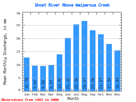
| Statistic | Jan | Feb | Mar | Apr | May | Jun | Jul | Aug | Sep | Oct | Nov | Dec | Annual |
|---|---|---|---|---|---|---|---|---|---|---|---|---|---|
| Mean | 12.78 | 9.69 | 9.56 | 9.97 | 13.92 | 20.12 | 25.35 | 26.56 | 23.05 | 21.57 | 17.93 | 15.44 | 206.24 |
| Standard Deviation | 2.05 | 1.50 | 1.30 | 1.52 | 10.62 | 14.37 | 10.86 | 9.21 | 4.92 | 4.41 | 3.18 | 2.74 | 48.54 |
| Min | 10.14 | 7.58 | 7.88 | 8.00 | 7.49 | 7.09 | 11.24 | 15.15 | 15.25 | 14.49 | 12.80 | 11.63 | 138.32 |
| Max | 17.52 | 12.95 | 12.73 | 13.28 | 53.62 | 65.60 | 44.25 | 53.95 | 34.56 | 32.57 | 24.75 | 21.10 | 308.73 |
| Coefficient of Variation | 0.16 | 0.15 | 0.14 | 0.15 | 0.76 | 0.71 | 0.43 | 0.35 | 0.21 | 0.20 | 0.18 | 0.18 | 0.23 |
 Return to R-Arctic Net Home Page