|
|
|||||||||||||||||
| Point ID: 2786 | Downloads | Plots | Site Data | Code: 04AB001 |
|
|
|||||||||||||||||
| Download | |
|---|---|
| Site Descriptor Information | Site Time Series Data |
| Link to all available data | |
|
|
| View: | Statistics | Time Series |
| Units: | mm |
| Statistic | Jan | Feb | Mar | Apr | May | Jun | Jul | Aug | Sep | Oct | Nov | Dec | Annual |
|---|---|---|---|---|---|---|---|---|---|---|---|---|---|
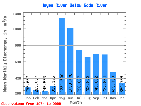
| Mean | 295.67 | 263.04 | 245.59 | 319.18 | 1231.50 | 1093.48 | 796.67 | 703.87 | 745.68 | 737.86 | 499.75 | 354.77 | 624.67 |
| Standard Deviation | 89.95 | 79.55 | 72.62 | 167.72 | 379.41 | 592.44 | 290.68 | 217.51 | 240.21 | 331.09 | 175.35 | 106.87 | 120.06 |
| Min | 135.00 | 114.00 | 101.00 | 94.40 | 422.00 | 308.00 | 362.00 | 312.00 | 296.00 | 291.00 | 229.00 | 173.00 | 438.67 |
| Max | 514.00 | 466.00 | 418.00 | 924.00 | 1880.00 | 2610.00 | 1710.00 | 1170.00 | 1220.00 | 1880.00 | 1090.00 | 656.00 | 903.42 |
| Coefficient of Variation | 0.30 | 0.30 | 0.30 | 0.53 | 0.31 | 0.54 | 0.36 | 0.31 | 0.32 | 0.45 | 0.35 | 0.30 | 0.19 |
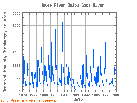
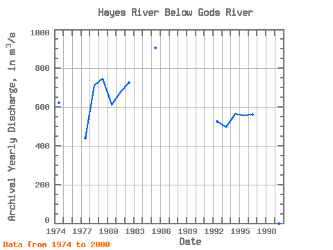
| Year | Jan | Feb | Mar | Apr | May | Jun | Jul | Aug | Sep | Oct | Nov | Dec | Annual | 1974 | 350.00 | 317.00 | 293.00 | 345.00 | 1250.00 | 1440.00 | 940.00 | 687.00 | 749.00 | 537.00 | 299.00 | 244.00 | 620.92 | 1975 | 232.00 | 225.00 | 217.00 | 325.00 | 1320.00 | 843.00 | 612.00 | 828.00 | 829.00 | 1976 | 341.00 | 280.00 | 257.00 | 305.00 | 521.00 | 724.00 | 598.00 | 902.00 | 590.00 | 356.00 | 231.00 | 1977 | 187.00 | 175.00 | 163.00 | 550.00 | 650.00 | 505.00 | 492.00 | 466.00 | 751.00 | 600.00 | 445.00 | 280.00 | 438.67 | 1978 | 210.00 | 186.00 | 170.00 | 183.00 | 1210.00 | 891.00 | 1020.00 | 1170.00 | 1220.00 | 1150.00 | 676.00 | 435.00 | 710.08 | 1979 | 340.00 | 318.00 | 295.00 | 309.00 | 1360.00 | 1680.00 | 1300.00 | 906.00 | 674.00 | 709.00 | 601.00 | 481.00 | 747.75 | 1980 | 394.00 | 331.00 | 291.00 | 511.00 | 1020.00 | 778.00 | 738.00 | 627.00 | 984.00 | 921.00 | 422.00 | 321.00 | 611.50 | 1981 | 302.00 | 269.00 | 244.00 | 231.00 | 1390.00 | 1310.00 | 943.00 | 803.00 | 535.00 | 998.00 | 590.00 | 550.00 | 680.42 | 1982 | 514.00 | 466.00 | 418.00 | 372.00 | 1880.00 | 1250.00 | 656.00 | 665.00 | 723.00 | 720.00 | 596.00 | 456.00 | 726.33 | 1983 | 393.00 | 348.00 | 311.00 | 283.00 | 1450.00 | 2340.00 | 989.00 | 860.00 | 987.00 | 650.00 | 423.00 | 1984 | 337.00 | 296.00 | 276.00 | 1060.00 | 679.00 | 382.00 | 434.00 | 481.00 | 413.00 | 357.00 | 1985 | 307.00 | 262.00 | 219.00 | 470.00 | 1630.00 | 2610.00 | 1710.00 | 846.00 | 737.00 | 945.00 | 668.00 | 437.00 | 903.42 | 1986 | 339.00 | 301.00 | 281.00 | 275.00 | 1050.00 | 944.00 | 1050.00 | 844.00 | 729.00 | 450.00 | 339.00 | 1987 | 287.00 | 271.00 | 264.00 | 924.00 | 915.00 | 522.00 | 728.00 | 494.00 | 330.00 | 1988 | 256.00 | 223.00 | 205.00 | 197.00 | 476.00 | 405.00 | 296.00 | 291.00 | 229.00 | 173.00 | 1989 | 135.00 | 114.00 | 101.00 | 94.40 | 369.00 | 278.00 | 1990 | 239.00 | 222.00 | 216.00 | 217.00 | 682.00 | 560.00 | 508.00 | 482.00 | 410.00 | 301.00 | 1991 | 231.00 | 191.00 | 166.00 | 186.00 | 1810.00 | 308.00 | 245.00 | 1992 | 171.00 | 150.00 | 153.00 | 172.00 | 1000.00 | 1390.00 | 670.00 | 511.00 | 705.00 | 685.00 | 386.00 | 291.00 | 523.67 | 1993 | 249.00 | 220.00 | 198.00 | 356.00 | 422.00 | 508.00 | 954.00 | 848.00 | 781.00 | 657.00 | 434.00 | 346.00 | 497.75 | 1994 | 277.00 | 234.00 | 231.00 | 239.00 | 1590.00 | 1160.00 | 775.00 | 532.00 | 425.00 | 433.00 | 540.00 | 345.00 | 565.08 | 1995 | 261.00 | 226.00 | 232.00 | 245.00 | 1250.00 | 597.00 | 362.00 | 876.00 | 1210.00 | 703.00 | 429.00 | 300.00 | 557.58 | 1996 | 233.00 | 194.00 | 168.00 | 175.00 | 1100.00 | 1350.00 | 789.00 | 624.00 | 628.00 | 560.00 | 482.00 | 420.00 | 560.25 | 1997 | 367.00 | 330.00 | 290.00 | 253.00 | 682.00 | 789.00 | 1040.00 | 1880.00 | 1090.00 | 656.00 | 1998 | 506.00 | 438.00 | 405.00 | 410.00 | 308.00 | 1999 | 268.00 | 263.00 | 318.00 | 388.00 | 312.00 | 543.00 | 470.00 | 331.00 | 270.00 | 2000 | 257.00 | 252.00 | 249.00 | 352.00 | 920.00 | 850.00 | 867.00 | 844.00 | 887.00 | 705.00 | 634.00 | 407.00 | 602.00 |
|---|
 Return to R-Arctic Net Home Page