|
|
|||||||||||||||||
| Point ID: 2776 | Downloads | Plots | Site Data | Other Close Sites | Code: 10CC002 |
|
|
|||||||||||||||||
| Download | |
|---|---|
| Site Descriptor Information | Site Time Series Data |
| Link to all available data | |
|
|
| View: | Statistics | Time Series |
| Units: | mm |
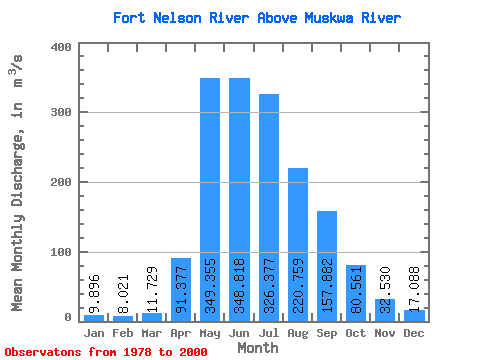
| Statistic | Jan | Feb | Mar | Apr | May | Jun | Jul | Aug | Sep | Oct | Nov | Dec | Annual |
|---|---|---|---|---|---|---|---|---|---|---|---|---|---|
| Mean | 9.90 | 8.02 | 11.73 | 91.38 | 349.36 | 348.82 | 326.38 | 220.76 | 157.88 | 80.56 | 32.53 | 17.09 | 137.90 |
| Standard Deviation | 3.48 | 2.89 | 17.01 | 72.73 | 200.01 | 169.32 | 256.04 | 216.47 | 152.31 | 59.96 | 16.16 | 7.06 | 61.11 |
| Min | 3.71 | 3.63 | 3.44 | 7.79 | 65.20 | 127.00 | 94.30 | 44.30 | 29.00 | 21.30 | 12.40 | 4.61 | 53.43 |
| Max | 18.20 | 16.00 | 86.00 | 271.00 | 716.00 | 689.00 | 1300.00 | 782.00 | 589.00 | 300.00 | 78.40 | 31.60 | 301.09 |
| Coefficient of Variation | 0.35 | 0.36 | 1.45 | 0.80 | 0.57 | 0.48 | 0.78 | 0.98 | 0.96 | 0.74 | 0.50 | 0.41 | 0.44 |
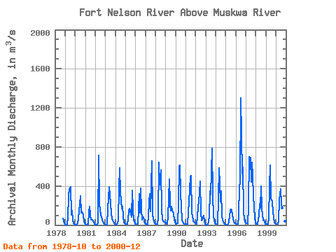
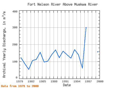
| Year | Jan | Feb | Mar | Apr | May | Jun | Jul | Aug | Sep | Oct | Nov | Dec | Annual | 1978 | 66.80 | 36.80 | 19.00 | 1979 | 6.60 | 3.63 | 4.39 | 78.00 | 297.00 | 367.00 | 392.00 | 101.00 | 144.00 | 50.60 | 15.20 | 4.61 | 122.00 | 1980 | 3.71 | 4.09 | 4.05 | 20.90 | 65.20 | 213.00 | 301.00 | 126.00 | 142.00 | 107.00 | 36.80 | 14.60 | 86.53 | 1981 | 9.77 | 6.11 | 6.02 | 7.79 | 131.00 | 193.00 | 105.00 | 51.70 | 57.10 | 37.70 | 23.90 | 12.10 | 53.43 | 1982 | 7.15 | 5.67 | 5.52 | 19.70 | 716.00 | 220.00 | 94.30 | 79.50 | 53.50 | 31.20 | 15.60 | 12.30 | 105.04 | 1983 | 7.12 | 5.66 | 5.66 | 165.00 | 389.00 | 315.00 | 209.00 | 123.00 | 63.30 | 36.90 | 15.80 | 8.21 | 111.97 | 1984 | 6.14 | 6.31 | 7.01 | 50.10 | 378.00 | 587.00 | 335.00 | 171.00 | 192.00 | 87.00 | 22.50 | 14.80 | 154.74 | 1985 | 10.10 | 7.71 | 8.53 | 50.30 | 149.00 | 166.00 | 115.00 | 79.90 | 352.00 | 151.00 | 46.10 | 21.10 | 96.39 | 1986 | 12.30 | 9.18 | 9.39 | 12.10 | 320.00 | 127.00 | 379.00 | 157.00 | 57.10 | 84.50 | 36.40 | 18.10 | 101.84 | 1987 | 11.10 | 8.04 | 7.14 | 87.40 | 236.00 | 317.00 | 140.00 | 653.00 | 111.00 | 58.10 | 30.70 | 18.00 | 139.79 | 1988 | 11.10 | 7.62 | 7.75 | 67.20 | 640.00 | 410.00 | 563.00 | 144.00 | 59.70 | 42.50 | 32.70 | 31.60 | 168.10 | 1989 | 15.00 | 9.94 | 7.52 | 81.40 | 468.00 | 208.00 | 146.00 | 189.00 | 150.00 | 122.00 | 46.60 | 28.80 | 122.69 | 1990 | 12.30 | 9.97 | 21.20 | 220.00 | 602.00 | 613.00 | 325.00 | 50.60 | 29.00 | 21.30 | 12.90 | 10.50 | 160.65 | 1991 | 7.67 | 7.40 | 8.13 | 131.00 | 237.00 | 489.00 | 505.00 | 110.00 | 95.20 | 40.90 | 21.90 | 16.60 | 139.15 | 1992 | 12.90 | 13.40 | 86.00 | 185.00 | 318.00 | 451.00 | 120.00 | 44.30 | 53.40 | 95.60 | 39.50 | 12.70 | 119.32 | 1993 | 5.80 | 5.43 | 3.44 | 40.50 | 79.80 | 348.00 | 311.00 | 782.00 | 301.00 | 97.00 | 50.10 | 21.10 | 170.43 | 1994 | 14.00 | 10.10 | 11.20 | 271.00 | 586.00 | 237.00 | 348.00 | 95.70 | 44.40 | 32.20 | 12.40 | 10.20 | 139.35 | 1995 | 6.86 | 6.30 | 5.87 | 22.60 | 99.80 | 144.00 | 163.00 | 144.00 | 61.70 | 36.10 | 21.00 | 14.40 | 60.47 | 1996 | 9.84 | 8.24 | 8.67 | 88.10 | 405.00 | 422.00 | 1300.00 | 525.00 | 589.00 | 139.00 | 59.30 | 29.70 | 298.65 | 1997 | 18.20 | 16.00 | 13.10 | 189.00 | 698.00 | 689.00 | 444.00 | 641.00 | 498.00 | 300.00 | 78.40 | 28.40 | 301.09 | 1998 | 12.50 | 10.50 | 10.80 | 97.90 | 221.00 | 175.00 | 397.00 | 172.00 | 44.00 | 51.30 | 29.10 | 14.10 | 102.93 | 1999 | 9.16 | 7.92 | 7.08 | 75.40 | 392.00 | 616.00 | 276.00 | 238.00 | 136.00 | 74.60 | 27.90 | 16.80 | 156.41 | 2000 | 8.39 | 7.24 | 9.56 | 49.90 | 258.00 | 367.00 | 212.00 | 179.00 | 240.00 | 89.60 | 36.60 | 15.30 | 122.72 |
|---|
| Other Close Sites | ||||||
|---|---|---|---|---|---|---|
| PointID | Latitude | Longitude | Drainage Area | Source | Name | |
| 2775 | "FORT NELSON RIVER AT FORT NELSON" | 58.82 | 1842029 | Hydat | ||
| 2777 | "MUSKWA RIVER NEAR FORT NELSON" | 58.78 | 1849879 | Hydat | ||
 Return to R-Arctic Net Home Page