|
|
|||||||||||||||||
| Point ID: 2760 | Downloads | Plots | Site Data | Code: 10BC001 |
|
|
|||||||||||||||||
| Download | |
|---|---|
| Site Descriptor Information | Site Time Series Data |
| Link to all available data | |
|
|
| View: | Statistics | Time Series |
| Units: | mm |
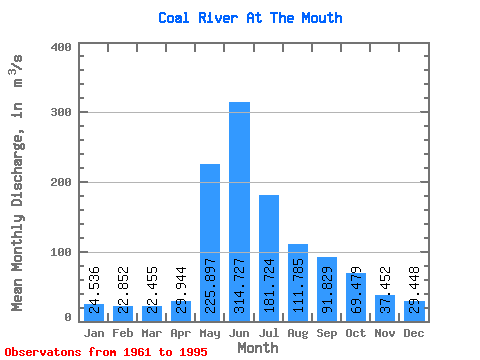
| Statistic | Jan | Feb | Mar | Apr | May | Jun | Jul | Aug | Sep | Oct | Nov | Dec | Annual |
|---|---|---|---|---|---|---|---|---|---|---|---|---|---|
| Mean | 24.54 | 22.85 | 22.45 | 29.94 | 225.90 | 314.73 | 181.72 | 111.78 | 91.83 | 69.48 | 37.45 | 29.45 | 97.54 |
| Standard Deviation | 4.51 | 4.08 | 4.12 | 8.31 | 58.69 | 92.65 | 69.77 | 37.73 | 29.86 | 18.13 | 11.44 | 6.26 | 18.80 |
| Min | 16.40 | 13.60 | 13.70 | 18.00 | 78.70 | 145.00 | 93.90 | 59.90 | 54.20 | 40.80 | 19.80 | 19.80 | 66.33 |
| Max | 35.10 | 31.70 | 30.90 | 46.70 | 339.00 | 517.00 | 355.00 | 209.00 | 200.00 | 111.00 | 63.30 | 41.60 | 129.33 |
| Coefficient of Variation | 0.18 | 0.18 | 0.18 | 0.28 | 0.26 | 0.29 | 0.38 | 0.34 | 0.33 | 0.26 | 0.30 | 0.21 | 0.19 |
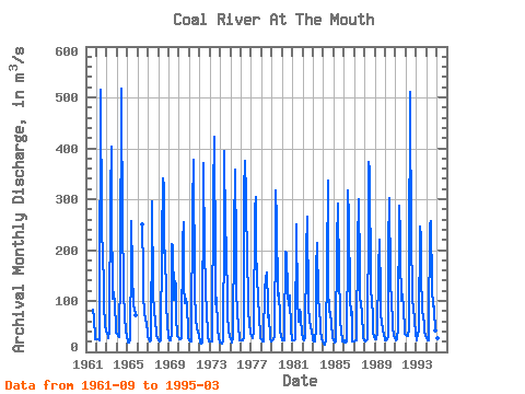
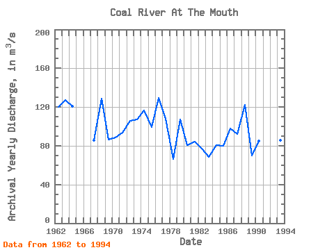
| Year | Jan | Feb | Mar | Apr | May | Jun | Jul | Aug | Sep | Oct | Nov | Dec | Annual | 1961 | 81.80 | 67.00 | 24.90 | 24.90 | 1962 | 24.90 | 24.90 | 24.50 | 22.40 | 78.70 | 515.00 | 240.00 | 189.00 | 132.00 | 96.20 | 49.80 | 41.60 | 119.92 | 1963 | 35.10 | 31.10 | 27.20 | 41.20 | 309.00 | 404.00 | 284.00 | 104.00 | 117.00 | 93.00 | 46.20 | 38.40 | 127.52 | 1964 | 34.80 | 31.70 | 29.40 | 28.00 | 160.00 | 517.00 | 229.00 | 157.00 | 120.00 | 69.00 | 38.80 | 30.60 | 120.44 | 1965 | 19.00 | 20.00 | 19.00 | 24.40 | 188.00 | 257.00 | 157.00 | 89.60 | 84.90 | 72.20 | 1966 | 251.00 | 158.00 | 113.00 | 73.60 | 66.40 | 54.30 | 40.20 | 1967 | 29.60 | 23.90 | 21.20 | 21.60 | 252.00 | 296.00 | 118.00 | 74.80 | 67.60 | 66.20 | 31.60 | 28.60 | 85.92 | 1968 | 23.40 | 20.10 | 20.40 | 23.50 | 213.00 | 340.00 | 323.00 | 194.00 | 200.00 | 104.00 | 46.10 | 38.70 | 128.85 | 1969 | 28.10 | 22.70 | 21.90 | 35.10 | 211.00 | 210.00 | 103.00 | 139.00 | 133.00 | 72.00 | 30.30 | 29.70 | 86.32 | 1970 | 24.80 | 24.10 | 24.70 | 26.00 | 218.00 | 254.00 | 132.00 | 95.80 | 105.00 | 91.50 | 40.20 | 29.50 | 88.80 | 1971 | 23.00 | 21.30 | 20.20 | 25.50 | 285.00 | 377.00 | 120.00 | 65.90 | 64.90 | 44.40 | 40.90 | 30.20 | 93.19 | 1972 | 18.90 | 17.30 | 15.70 | 18.00 | 339.00 | 370.00 | 197.00 | 130.00 | 67.40 | 47.40 | 29.70 | 21.20 | 105.97 | 1973 | 20.70 | 19.70 | 19.70 | 28.50 | 310.00 | 423.00 | 170.00 | 93.90 | 106.00 | 47.70 | 25.00 | 21.50 | 107.14 | 1974 | 18.40 | 17.30 | 16.00 | 20.30 | 251.00 | 394.00 | 240.00 | 209.00 | 90.50 | 70.70 | 43.60 | 29.00 | 116.65 | 1975 | 25.20 | 22.50 | 19.30 | 28.00 | 237.00 | 358.00 | 202.00 | 124.00 | 74.30 | 53.20 | 22.60 | 24.20 | 99.19 | 1976 | 22.80 | 22.10 | 22.20 | 26.70 | 314.00 | 376.00 | 306.00 | 165.00 | 128.00 | 77.60 | 56.80 | 34.80 | 129.33 | 1977 | 30.50 | 27.60 | 26.70 | 40.40 | 280.00 | 305.00 | 199.00 | 147.00 | 106.00 | 69.80 | 33.90 | 26.00 | 107.66 | 1978 | 23.70 | 20.70 | 19.60 | 28.40 | 122.00 | 145.00 | 156.00 | 92.50 | 67.50 | 72.50 | 27.20 | 20.80 | 66.33 | 1979 | 22.10 | 21.80 | 23.70 | 30.00 | 244.00 | 317.00 | 259.00 | 111.00 | 114.00 | 68.00 | 42.20 | 30.40 | 106.93 | 1980 | 23.10 | 22.60 | 21.60 | 32.00 | 197.00 | 193.00 | 114.00 | 91.10 | 92.90 | 111.00 | 39.20 | 26.10 | 80.30 | 1981 | 22.70 | 21.70 | 22.60 | 25.00 | 251.00 | 239.00 | 108.00 | 59.90 | 82.80 | 74.00 | 62.90 | 38.40 | 84.00 | 1982 | 25.00 | 24.90 | 23.10 | 26.80 | 198.00 | 266.00 | 93.90 | 89.00 | 61.80 | 49.90 | 36.90 | 29.80 | 77.09 | 1983 | 22.30 | 19.60 | 19.60 | 46.70 | 164.00 | 215.00 | 106.00 | 80.80 | 55.50 | 40.80 | 27.20 | 20.50 | 68.17 | 1984 | 16.40 | 13.60 | 13.70 | 23.50 | 168.00 | 336.00 | 125.00 | 78.50 | 79.50 | 52.40 | 31.70 | 27.00 | 80.44 | 1985 | 22.00 | 19.10 | 19.50 | 21.30 | 213.00 | 292.00 | 152.00 | 75.00 | 60.70 | 41.70 | 19.90 | 19.80 | 79.67 | 1986 | 23.60 | 19.00 | 17.80 | 20.10 | 215.00 | 318.00 | 262.00 | 106.00 | 71.00 | 77.80 | 19.80 | 20.40 | 97.54 | 1987 | 21.40 | 23.10 | 22.10 | 26.60 | 212.00 | 300.00 | 165.00 | 113.00 | 88.30 | 80.60 | 27.00 | 24.60 | 91.97 | 1988 | 23.10 | 21.40 | 22.20 | 25.70 | 280.00 | 373.00 | 355.00 | 128.00 | 96.00 | 76.10 | 39.00 | 29.10 | 122.38 | 1989 | 25.30 | 24.10 | 24.80 | 38.40 | 162.00 | 221.00 | 110.00 | 75.90 | 54.20 | 45.20 | 30.30 | 27.70 | 69.91 | 1990 | 23.30 | 22.60 | 23.70 | 29.90 | 208.00 | 303.00 | 145.00 | 89.70 | 68.10 | 49.50 | 31.20 | 27.10 | 85.09 | 1991 | 23.50 | 24.10 | 25.00 | 46.00 | 287.00 | 230.00 | 187.00 | 101.00 | 113.00 | 83.20 | 44.50 | 34.90 | 99.93 | 1992 | 34.20 | 30.90 | 30.90 | 43.60 | 167.00 | 510.00 | 204.00 | 134.00 | 104.00 | 85.50 | 63.30 | 35.10 | 120.21 | 1993 | 22.60 | 29.70 | 30.30 | 43.60 | 247.00 | 225.00 | 152.00 | 84.00 | 63.20 | 62.30 | 37.20 | 33.70 | 85.88 | 1994 | 26.00 | 22.40 | 23.60 | 41.00 | 248.00 | 256.00 | 125.00 | 88.50 | 97.70 | 83.50 | 41.70 | 37.30 | 90.89 | 1995 | 30.20 | 26.50 | 29.10 |
|---|
 Return to R-Arctic Net Home Page