|
|
|||||||||||||||||
| Point ID: 2759 | Downloads | Plots | Site Data | Code: 10BB002 |
|
|
|||||||||||||||||
| Download | |
|---|---|
| Site Descriptor Information | Site Time Series Data |
| Link to all available data | |
|
|
| View: | Statistics | Time Series |
| Units: | mm |
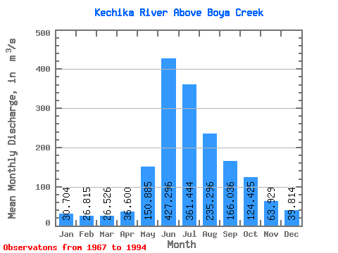
| Statistic | Jan | Feb | Mar | Apr | May | Jun | Jul | Aug | Sep | Oct | Nov | Dec | Annual |
|---|---|---|---|---|---|---|---|---|---|---|---|---|---|
| Mean | 30.70 | 26.82 | 26.53 | 36.60 | 150.88 | 427.30 | 361.44 | 235.30 | 166.04 | 124.42 | 63.93 | 39.81 | 140.66 |
| Standard Deviation | 5.62 | 4.69 | 4.52 | 7.80 | 52.43 | 86.72 | 82.44 | 44.66 | 37.50 | 34.76 | 12.62 | 6.77 | 14.82 |
| Min | 18.40 | 14.90 | 14.40 | 24.70 | 81.60 | 301.00 | 188.00 | 167.00 | 112.00 | 77.10 | 44.90 | 30.20 | 106.87 |
| Max | 42.20 | 36.60 | 35.20 | 54.80 | 300.00 | 624.00 | 488.00 | 345.00 | 252.00 | 205.00 | 92.10 | 61.30 | 170.87 |
| Coefficient of Variation | 0.18 | 0.17 | 0.17 | 0.21 | 0.35 | 0.20 | 0.23 | 0.19 | 0.23 | 0.28 | 0.20 | 0.17 | 0.10 |
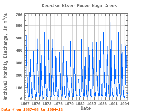
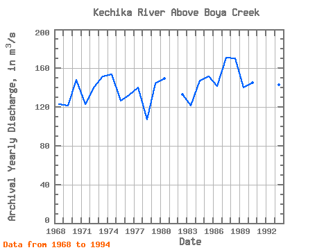
| Year | Jan | Feb | Mar | Apr | May | Jun | Jul | Aug | Sep | Oct | Nov | Dec | Annual | 1967 | 520.00 | 331.00 | 215.00 | 155.00 | 122.00 | 65.50 | 42.90 | 1968 | 26.30 | 24.20 | 24.80 | 30.90 | 148.00 | 304.00 | 331.00 | 193.00 | 185.00 | 104.00 | 65.20 | 36.70 | 122.76 | 1969 | 23.70 | 21.80 | 21.20 | 37.30 | 151.00 | 389.00 | 227.00 | 230.00 | 168.00 | 103.00 | 54.10 | 35.20 | 121.78 | 1970 | 27.70 | 26.60 | 27.30 | 31.60 | 97.00 | 493.00 | 327.00 | 259.00 | 204.00 | 165.00 | 79.00 | 40.70 | 148.16 | 1971 | 30.50 | 26.10 | 25.20 | 31.30 | 143.00 | 451.00 | 268.00 | 200.00 | 131.00 | 88.50 | 51.80 | 30.20 | 123.05 | 1972 | 18.40 | 14.90 | 14.40 | 24.70 | 164.00 | 548.00 | 299.00 | 251.00 | 142.00 | 125.00 | 54.00 | 35.00 | 140.87 | 1973 | 29.70 | 26.00 | 26.40 | 30.30 | 165.00 | 486.00 | 443.00 | 239.00 | 198.00 | 94.40 | 48.10 | 36.70 | 151.88 | 1974 | 29.50 | 26.40 | 25.80 | 29.10 | 96.90 | 301.00 | 488.00 | 345.00 | 178.00 | 186.00 | 90.40 | 46.80 | 153.57 | 1975 | 39.00 | 36.60 | 32.70 | 33.50 | 95.30 | 310.00 | 402.00 | 277.00 | 126.00 | 88.10 | 44.90 | 37.10 | 126.85 | 1976 | 30.50 | 25.60 | 23.90 | 33.70 | 146.00 | 311.00 | 384.00 | 264.00 | 163.00 | 103.00 | 62.00 | 37.10 | 131.98 | 1977 | 34.40 | 29.00 | 25.40 | 46.10 | 167.00 | 436.00 | 372.00 | 255.00 | 129.00 | 95.10 | 56.00 | 33.00 | 139.83 | 1978 | 24.90 | 21.90 | 21.30 | 35.20 | 81.60 | 315.00 | 188.00 | 198.00 | 161.00 | 125.00 | 66.40 | 44.10 | 106.87 | 1979 | 33.10 | 25.20 | 29.30 | 32.90 | 117.00 | 426.00 | 472.00 | 217.00 | 152.00 | 120.00 | 75.80 | 36.90 | 144.77 | 1980 | 28.90 | 29.70 | 26.90 | 27.10 | 153.00 | 352.00 | 403.00 | 229.00 | 198.00 | 205.00 | 92.10 | 52.00 | 149.72 | 1981 | 42.20 | 36.30 | 35.20 | 166.00 | 104.00 | 72.70 | 36.60 | 1982 | 26.70 | 28.10 | 28.50 | 29.50 | 99.00 | 489.00 | 300.00 | 196.00 | 183.00 | 115.00 | 65.30 | 38.60 | 133.22 | 1983 | 31.10 | 28.90 | 27.00 | 31.60 | 123.00 | 418.00 | 272.00 | 202.00 | 140.00 | 95.70 | 56.40 | 31.50 | 121.43 | 1984 | 24.40 | 24.60 | 29.10 | 44.40 | 96.00 | 422.00 | 381.00 | 341.00 | 199.00 | 111.00 | 55.40 | 37.90 | 147.15 | 1985 | 32.20 | 23.60 | 25.50 | 34.90 | 142.00 | 353.00 | 467.00 | 217.00 | 252.00 | 161.00 | 63.70 | 43.30 | 151.27 | 1986 | 36.50 | 25.10 | 30.20 | 36.30 | 86.20 | 369.00 | 464.00 | 203.00 | 112.00 | 192.00 | 86.80 | 61.30 | 141.87 | 1987 | 41.30 | 32.10 | 32.20 | 36.30 | 165.00 | 472.00 | 468.00 | 276.00 | 241.00 | 188.00 | 61.40 | 37.10 | 170.87 | 1988 | 34.90 | 31.40 | 32.00 | 46.00 | 225.00 | 542.00 | 451.00 | 288.00 | 156.00 | 114.00 | 74.30 | 45.50 | 170.01 | 1989 | 32.70 | 29.20 | 26.80 | 45.40 | 217.00 | 436.00 | 297.00 | 249.00 | 141.00 | 103.00 | 63.30 | 37.80 | 139.85 | 1990 | 30.50 | 27.30 | 27.70 | 32.60 | 198.00 | 624.00 | 332.00 | 188.00 | 119.00 | 77.10 | 50.10 | 36.30 | 145.22 | 1991 | 30.40 | 27.10 | 25.60 | 46.60 | 219.00 | 359.00 | 308.00 | 184.00 | 196.00 | 140.00 | 72.70 | 48.20 | 138.05 | 1992 | 38.00 | 32.70 | 30.90 | 54.80 | 126.00 | 545.00 | 310.00 | 167.00 | 112.00 | 130.00 | 56.90 | 40.30 | 136.97 | 1993 | 27.40 | 23.40 | 22.80 | 51.70 | 300.00 | 448.00 | 320.00 | 208.00 | 126.00 | 104.00 | 52.50 | 31.10 | 142.91 | 1994 | 24.10 | 20.20 | 18.10 | 37.80 | 202.00 | 418.00 | 454.00 | 262.00 | 216.00 | 125.00 | 53.20 | 44.90 | 156.28 |
|---|
 Return to R-Arctic Net Home Page