|
|
|||||||||||||||||
| Point ID: 2757 | Downloads | Plots | Site Data | Code: 10BA001 |
|
|
|||||||||||||||||
| Download | |
|---|---|
| Site Descriptor Information | Site Time Series Data |
| Link to all available data | |
|

|
| View: | Statistics | Time Series |
| Units: | mm |
| Statistic | Jan | Feb | Mar | Apr | May | Jun | Jul | Aug | Sep | Oct | Nov | Dec | Annual |
|---|---|---|---|---|---|---|---|---|---|---|---|---|---|
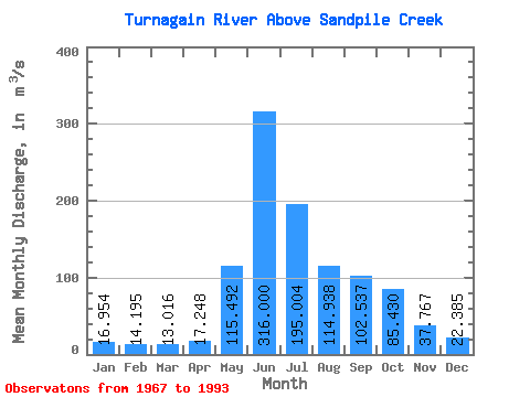
| Mean | 16.95 | 14.20 | 13.02 | 17.25 | 115.49 | 316.00 | 195.00 | 114.94 | 102.54 | 85.43 | 37.77 | 22.39 | 87.45 |
| Standard Deviation | 4.33 | 3.18 | 2.89 | 4.06 | 56.42 | 67.25 | 58.27 | 33.53 | 30.54 | 32.80 | 12.03 | 6.29 | 10.30 |
| Min | 10.10 | 6.38 | 6.01 | 5.85 | 37.20 | 192.00 | 84.10 | 72.10 | 48.20 | 44.40 | 22.30 | 15.40 | 56.53 |
| Max | 27.70 | 19.90 | 18.20 | 25.10 | 245.00 | 444.00 | 332.00 | 188.00 | 165.00 | 194.00 | 68.60 | 45.60 | 101.98 |
| Coefficient of Variation | 0.26 | 0.22 | 0.22 | 0.23 | 0.49 | 0.21 | 0.30 | 0.29 | 0.30 | 0.38 | 0.32 | 0.28 | 0.12 |
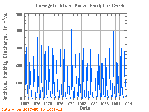
| Year | Jan | Feb | Mar | Apr | May | Jun | Jul | Aug | Sep | Oct | Nov | Dec | Annual | 1967 | 88.60 | 444.00 | 164.00 | 98.90 | 88.60 | 82.90 | 43.40 | 22.00 | 1968 | 13.50 | 12.60 | 12.90 | 15.40 | 118.00 | 218.00 | 171.00 | 89.20 | 165.00 | 76.90 | 40.30 | 21.50 | 79.53 | 1969 | 10.70 | 6.38 | 6.01 | 15.40 | 135.00 | 254.00 | 110.00 | 175.00 | 146.00 | 64.30 | 26.20 | 20.10 | 80.76 | 1970 | 16.20 | 14.90 | 14.10 | 16.00 | 64.10 | 359.00 | 182.00 | 151.00 | 121.00 | 107.00 | 43.90 | 21.80 | 92.58 | 1971 | 14.30 | 12.20 | 11.40 | 17.70 | 92.00 | 315.00 | 123.00 | 75.70 | 72.40 | 61.00 | 29.30 | 15.40 | 69.95 | 1972 | 10.10 | 10.00 | 9.21 | 13.90 | 138.00 | 396.00 | 170.00 | 133.00 | 103.00 | 112.00 | 40.00 | 20.80 | 96.33 | 1973 | 16.20 | 12.90 | 12.90 | 15.90 | 100.00 | 307.00 | 235.00 | 116.00 | 140.00 | 63.80 | 22.30 | 15.70 | 88.14 | 1974 | 13.10 | 12.70 | 12.40 | 13.10 | 61.30 | 267.00 | 332.00 | 188.00 | 95.10 | 142.00 | 61.70 | 25.40 | 101.98 | 1975 | 21.40 | 16.40 | 13.40 | 13.30 | 78.40 | 227.00 | 229.00 | 143.00 | 101.00 | 66.70 | 25.80 | 20.70 | 79.67 | 1976 | 17.80 | 14.10 | 12.70 | 16.20 | 93.10 | 289.00 | 254.00 | 135.00 | 114.00 | 69.40 | 39.30 | 21.80 | 89.70 | 1977 | 20.10 | 17.90 | 14.70 | 21.80 | 119.00 | 345.00 | 239.00 | 122.00 | 88.30 | 61.50 | 29.40 | 17.40 | 91.34 | 1978 | 12.90 | 11.50 | 10.60 | 13.50 | 54.70 | 192.00 | 84.10 | 76.10 | 80.30 | 82.40 | 37.30 | 23.00 | 56.53 | 1979 | 15.00 | 11.00 | 10.50 | 16.40 | 97.90 | 407.00 | 309.00 | 91.20 | 75.40 | 70.20 | 32.30 | 16.10 | 96.00 | 1980 | 12.80 | 12.80 | 11.60 | 16.40 | 134.00 | 265.00 | 218.00 | 159.00 | 117.00 | 131.00 | 55.30 | 30.30 | 96.93 | 1981 | 24.60 | 19.30 | 18.20 | 17.60 | 232.00 | 349.00 | 197.00 | 85.00 | 96.40 | 83.90 | 57.00 | 20.20 | 100.02 | 1982 | 13.20 | 12.40 | 7.29 | 5.85 | 37.20 | 420.00 | 179.00 | 105.00 | 110.00 | 77.30 | 33.30 | 20.10 | 85.05 | 1983 | 16.80 | 15.40 | 14.90 | 21.50 | 109.00 | 275.00 | 143.00 | 112.00 | 110.00 | 68.70 | 34.00 | 16.60 | 78.08 | 1984 | 12.40 | 12.10 | 11.50 | 18.70 | 45.10 | 295.00 | 194.00 | 169.00 | 134.00 | 69.40 | 24.00 | 17.70 | 83.58 | 1985 | 15.00 | 11.80 | 12.70 | 14.30 | 123.00 | 82.70 | 27.50 | 20.00 | 1986 | 18.80 | 12.90 | 13.50 | 16.30 | 50.60 | 282.00 | 246.00 | 98.50 | 80.60 | 194.00 | 68.60 | 45.60 | 93.95 | 1987 | 27.70 | 19.90 | 15.10 | 17.50 | 101.00 | 320.00 | 239.00 | 122.00 | 118.00 | 127.00 | 37.50 | 25.50 | 97.52 | 1988 | 20.00 | 16.60 | 15.90 | 20.20 | 154.00 | 330.00 | 249.00 | 129.00 | 84.90 | 75.70 | 40.90 | 29.90 | 97.17 | 1989 | 20.30 | 16.60 | 15.50 | 25.10 | 217.00 | 299.00 | 140.00 | 85.70 | 61.40 | 56.10 | 35.10 | 24.70 | 83.04 | 1990 | 20.10 | 18.30 | 17.50 | 19.70 | 175.00 | 396.00 | 180.00 | 83.60 | 68.50 | 44.40 | 27.40 | 21.90 | 89.37 | 1991 | 18.00 | 15.80 | 14.70 | 21.30 | 174.00 | 267.00 | 159.00 | 94.30 | 164.00 | 110.00 | 50.10 | 30.60 | 93.23 | 1992 | 22.70 | 18.50 | 17.00 | 24.70 | 88.80 | 420.00 | 173.00 | 72.10 | 62.40 | 71.80 | 32.40 | 23.30 | 85.56 | 1993 | 17.10 | 14.10 | 12.20 | 20.70 | 245.00 | 278.00 | 151.00 | 79.10 | 48.20 | 54.50 | 25.40 | 16.30 | 80.13 |
|---|
 Return to R-Arctic Net Home Page