|
|
|||||||||||||||||
| Point ID: 2745 | Downloads | Plots | Site Data | Code: 09AA010 |
|
|
|||||||||||||||||
| Download | |
|---|---|
| Site Descriptor Information | Site Time Series Data |
| Link to all available data | |
| View: | Time Series | All |
| Units: | m3/s |
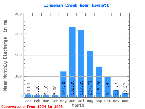
| Statistic | Jan | Feb | Mar | Apr | May | Jun | Jul | Aug | Sep | Oct | Nov | Dec | Annual |
|---|---|---|---|---|---|---|---|---|---|---|---|---|---|
| Mean | 13.84 | 9.47 | 9.16 | 8.99 | 122.31 | 332.39 | 319.19 | 220.74 | 145.20 | 94.78 | 33.77 | 19.28 | 1309.60 |
| Standard Deviation | 4.46 | 3.17 | 6.41 | 6.46 | 64.55 | 63.45 | 67.42 | 35.02 | 58.11 | 37.77 | 16.35 | 6.21 | 144.36 |
| Min | 6.45 | 1.54 | 2.34 | 4.60 | 23.99 | 205.20 | 208.66 | 157.33 | 55.62 | 42.62 | 11.88 | 7.09 | 1069.14 |
| Max | 28.01 | 15.15 | 39.39 | 35.75 | 309.09 | 503.28 | 458.61 | 332.52 | 334.80 | 184.11 | 79.16 | 35.04 | 1599.61 |
| Coefficient of Variation | 0.32 | 0.34 | 0.70 | 0.72 | 0.53 | 0.19 | 0.21 | 0.16 | 0.40 | 0.40 | 0.48 | 0.32 | 0.11 |
 Return to R-Arctic Net Home Page