|
|
|||||||||||||||||
| Point ID: 234 | Downloads | Plots | Site Data | Code: 05BB001 |
|
|
|||||||||||||||||
| Download | |
|---|---|
| Site Descriptor Information | Site Time Series Data |
| Link to all available data | |
| View: | Time Series | All |
| Units: | m3/s |
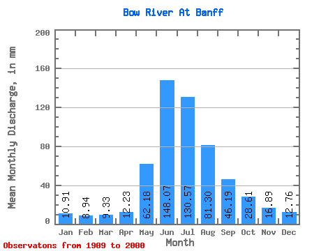
| Statistic | Jan | Feb | Mar | Apr | May | Jun | Jul | Aug | Sep | Oct | Nov | Dec | Annual |
|---|---|---|---|---|---|---|---|---|---|---|---|---|---|
| Mean | 10.90 | 9.01 | 9.33 | 12.23 | 62.17 | 148.07 | 130.55 | 81.29 | 46.19 | 28.61 | 16.89 | 12.76 | 563.06 |
| Standard Deviation | 1.47 | 1.30 | 1.09 | 3.62 | 25.97 | 36.36 | 32.28 | 15.35 | 8.70 | 5.24 | 2.88 | 1.81 | 73.35 |
| Min | 6.81 | 5.98 | 6.67 | 7.56 | 22.78 | 79.40 | 64.71 | 54.41 | 29.20 | 18.54 | 10.87 | 8.43 | 398.45 |
| Max | 15.39 | 13.47 | 11.94 | 33.90 | 139.35 | 246.30 | 222.97 | 122.39 | 84.09 | 42.65 | 27.21 | 17.81 | 726.49 |
| Coefficient of Variation | 0.14 | 0.14 | 0.12 | 0.30 | 0.42 | 0.25 | 0.25 | 0.19 | 0.19 | 0.18 | 0.17 | 0.14 | 0.13 |
 Return to R-Arctic Net Home Page