|
|
|||||||||||||||||
| Point ID: 182 | Downloads | Plots | Site Data | Code: 05AG012 |
|
|
|||||||||||||||||
| Download | |
|---|---|
| Site Descriptor Information | Site Time Series Data |
| Link to all available data | |
|
|
| View: | Statistics | Time Series |
| Units: | mm |
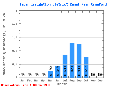
| Statistic | Jan | Feb | Mar | Apr | May | Jun | Jul | Aug | Sep | Oct | Nov | Dec | Annual |
|---|---|---|---|---|---|---|---|---|---|---|---|---|---|
| Mean | 0.19 | 0.35 | 0.69 | 1.03 | 1.00 | 0.62 | |||||||
| Standard Deviation | 0.07 | 0.39 | 0.09 | 0.40 | 0.42 | 0.31 | |||||||
| Min | 0.14 | 0.02 | 0.59 | 0.57 | 0.56 | 0.27 | |||||||
| Max | 0.24 | 0.78 | 0.76 | 1.28 | 1.40 | 0.86 | |||||||
| Coefficient of Variation | 0.36 | 1.11 | 0.13 | 0.38 | 0.42 | 0.50 |
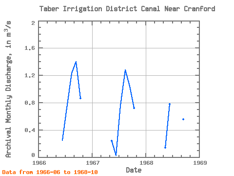
| Year | Jan | Feb | Mar | Apr | May | Jun | Jul | Aug | Sep | Oct | Nov | Dec | Annual | 1966 | 0.25 | 0.72 | 1.23 | 1.40 | 0.86 | 1967 | 0.24 | 0.02 | 0.76 | 1.28 | 1.04 | 0.72 | 1968 | 0.14 | 0.78 | 0.59 | 0.57 | 0.56 | 0.27 |
|---|
 Return to R-Arctic Net Home Page