|
|
|||||||||||||||||
| Point ID: 9738 | Downloads | Plots | Site Data | Code: 05079000 |
|
|
|||||||||||||||||
| Download | |
|---|---|
| Site Descriptor Information | Site Time Series Data |
| Link to all available data | |
| View: | Time Series | All |
| Units: | mm |
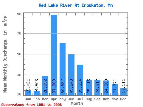
| Statistic | Jan | Feb | Mar | Apr | May | Jun | Jul | Aug | Sep | Oct | Nov | Dec | Annual |
|---|---|---|---|---|---|---|---|---|---|---|---|---|---|
| Mean | 15.02 | 14.50 | 28.89 | 87.86 | 60.69 | 49.64 | 39.62 | 25.11 | 24.92 | 24.50 | 21.37 | 17.11 | 34.13 |
| Standard Deviation | 11.13 | 10.89 | 25.89 | 70.87 | 58.53 | 38.33 | 36.91 | 22.46 | 22.30 | 19.60 | 18.25 | 12.84 | 21.25 |
| Min | 0.44 | 0.50 | 0.71 | 6.56 | 4.35 | 2.28 | 0.74 | 0.35 | 0.25 | 0.23 | 0.29 | 0.15 | 2.41 |
| Max | 47.09 | 50.33 | 120.56 | 336.21 | 433.05 | 204.02 | 193.99 | 109.54 | 153.15 | 80.31 | 102.50 | 53.79 | 96.53 |
| Coefficient of Variation | 0.74 | 0.75 | 0.90 | 0.81 | 0.96 | 0.77 | 0.93 | 0.89 | 0.90 | 0.80 | 0.85 | 0.75 | 0.62 |
 Return to R-Arctic Net Home Page