|
|
|||||||||||||||||
| Point ID: 9738 | Downloads | Plots | Site Data | Code: 05079000 |
|
|
|||||||||||||||||
| Download | |
|---|---|
| Site Descriptor Information | Site Time Series Data |
| Link to all available data | |
| View: | Time Series | All |
| Units: | m3/s |
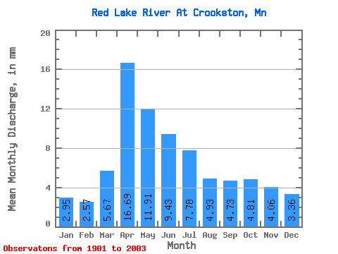
| Statistic | Jan | Feb | Mar | Apr | May | Jun | Jul | Aug | Sep | Oct | Nov | Dec | Annual |
|---|---|---|---|---|---|---|---|---|---|---|---|---|---|
| Mean | 2.95 | 2.59 | 5.67 | 16.68 | 11.91 | 9.43 | 7.77 | 4.93 | 4.73 | 4.81 | 4.06 | 3.36 | 78.91 |
| Standard Deviation | 2.18 | 1.95 | 5.08 | 13.46 | 11.48 | 7.28 | 7.24 | 4.41 | 4.24 | 3.85 | 3.47 | 2.52 | 49.14 |
| Min | 0.09 | 0.09 | 0.14 | 1.25 | 0.85 | 0.43 | 0.14 | 0.07 | 0.05 | 0.04 | 0.05 | 0.03 | 5.57 |
| Max | 9.24 | 9.00 | 23.65 | 63.85 | 84.97 | 38.74 | 38.06 | 21.49 | 29.08 | 15.76 | 19.46 | 10.55 | 223.19 |
| Coefficient of Variation | 0.74 | 0.75 | 0.90 | 0.81 | 0.96 | 0.77 | 0.93 | 0.89 | 0.90 | 0.80 | 0.85 | 0.75 | 0.62 |
 Return to R-Arctic Net Home Page