|
|
|||||||||||||||||
| Point ID: 9733 | Downloads | Plots | Site Data | Code: 05127000 |
|
|
|||||||||||||||||
| Download | |
|---|---|
| Site Descriptor Information | Site Time Series Data |
| Link to all available data | |
| View: | Time Series | All |
| Units: | mm |
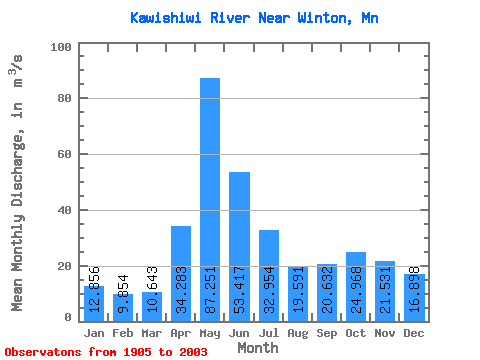
| Statistic | Jan | Feb | Mar | Apr | May | Jun | Jul | Aug | Sep | Oct | Nov | Dec | Annual |
|---|---|---|---|---|---|---|---|---|---|---|---|---|---|
| Mean | 12.86 | 9.85 | 10.64 | 34.28 | 87.25 | 53.42 | 32.95 | 19.59 | 20.63 | 24.97 | 21.53 | 16.90 | 29.32 |
| Standard Deviation | 5.68 | 4.05 | 4.16 | 27.21 | 50.35 | 30.33 | 18.13 | 15.37 | 17.74 | 23.05 | 16.94 | 8.60 | 8.52 |
| Min | 2.27 | 2.11 | 2.93 | 0.55 | 3.16 | 14.70 | 6.15 | 1.46 | 1.08 | 1.88 | 0.25 | 2.15 | 13.84 |
| Max | 24.41 | 21.81 | 23.91 | 142.14 | 262.74 | 160.30 | 95.78 | 106.90 | 89.18 | 121.12 | 101.15 | 40.28 | 52.21 |
| Coefficient of Variation | 0.44 | 0.41 | 0.39 | 0.79 | 0.58 | 0.57 | 0.55 | 0.78 | 0.86 | 0.92 | 0.79 | 0.51 | 0.29 |
 Return to R-Arctic Net Home Page