|
|
|||||||||||||||||
| Point ID: 9733 | Downloads | Plots | Site Data | Code: 05127000 |
|
|
|||||||||||||||||
| Download | |
|---|---|
| Site Descriptor Information | Site Time Series Data |
| Link to all available data | |
| View: | Time Series | All |
| Units: | m3/s |
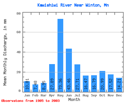
| Statistic | Jan | Feb | Mar | Apr | May | Jun | Jul | Aug | Sep | Oct | Nov | Dec | Annual |
|---|---|---|---|---|---|---|---|---|---|---|---|---|---|
| Mean | 10.81 | 7.55 | 8.95 | 27.89 | 73.35 | 43.46 | 27.70 | 16.47 | 16.79 | 20.99 | 17.52 | 14.21 | 290.42 |
| Standard Deviation | 4.78 | 3.10 | 3.50 | 22.14 | 42.32 | 24.68 | 15.24 | 12.92 | 14.44 | 19.38 | 13.78 | 7.23 | 84.38 |
| Min | 1.91 | 1.61 | 2.46 | 0.44 | 2.65 | 11.96 | 5.17 | 1.23 | 0.88 | 1.58 | 0.21 | 1.81 | 137.08 |
| Max | 20.52 | 16.70 | 20.10 | 115.65 | 220.86 | 130.43 | 80.52 | 89.86 | 72.56 | 101.82 | 82.30 | 33.86 | 517.26 |
| Coefficient of Variation | 0.44 | 0.41 | 0.39 | 0.79 | 0.58 | 0.57 | 0.55 | 0.78 | 0.86 | 0.92 | 0.79 | 0.51 | 0.29 |
 Return to R-Arctic Net Home Page