|
|
|||||||||||||||||
| Point ID: 9726 | Downloads | Plots | Site Data | Code: 05124000 |
|
|
|||||||||||||||||
| Download | |
|---|---|
| Site Descriptor Information | Site Time Series Data |
| Link to all available data | |
| View: | Time Series | All |
| Units: | mm |
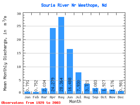
| Statistic | Jan | Feb | Mar | Apr | May | Jun | Jul | Aug | Sep | Oct | Nov | Dec | Annual |
|---|---|---|---|---|---|---|---|---|---|---|---|---|---|
| Mean | 0.79 | 0.75 | 2.03 | 24.28 | 28.36 | 16.49 | 7.93 | 3.72 | 2.08 | 1.93 | 1.58 | 0.98 | 7.71 |
| Standard Deviation | 1.14 | 1.11 | 3.81 | 39.04 | 41.64 | 27.95 | 11.70 | 5.17 | 2.93 | 2.68 | 2.32 | 1.37 | 9.85 |
| Min | 0.00 | 0.00 | 0.00 | 0.00 | 0.00 | 0.00 | 0.00 | 0.00 | 0.00 | 0.00 | 0.00 | 0.00 | 0.00 |
| Max | 5.41 | 5.38 | 22.07 | 250.59 | 168.97 | 139.29 | 48.88 | 28.71 | 18.60 | 13.39 | 10.95 | 5.68 | 46.07 |
| Coefficient of Variation | 1.44 | 1.48 | 1.87 | 1.61 | 1.47 | 1.69 | 1.48 | 1.39 | 1.41 | 1.39 | 1.47 | 1.40 | 1.28 |
 Return to R-Arctic Net Home Page