|
|
|||||||||||||||||
| Point ID: 9726 | Downloads | Plots | Site Data | Code: 05124000 |
|
|
|||||||||||||||||
| Download | |
|---|---|
| Site Descriptor Information | Site Time Series Data |
| Link to all available data | |
| View: | Time Series | All |
| Units: | m3/s |
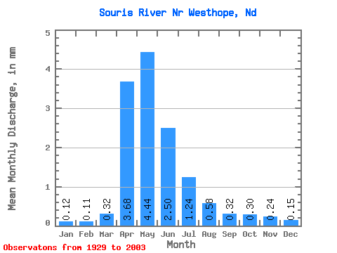
| Statistic | Jan | Feb | Mar | Apr | May | Jun | Jul | Aug | Sep | Oct | Nov | Dec | Annual |
|---|---|---|---|---|---|---|---|---|---|---|---|---|---|
| Mean | 0.05 | 0.04 | 0.12 | 1.44 | 1.73 | 0.98 | 0.48 | 0.23 | 0.12 | 0.12 | 0.09 | 0.06 | 5.56 |
| Standard Deviation | 0.07 | 0.06 | 0.23 | 2.31 | 2.55 | 1.66 | 0.72 | 0.32 | 0.17 | 0.16 | 0.14 | 0.08 | 7.10 |
| Min | 0.00 | 0.00 | 0.00 | 0.00 | 0.00 | 0.00 | 0.00 | 0.00 | 0.00 | 0.00 | 0.00 | 0.00 | 0.00 |
| Max | 0.33 | 0.30 | 1.35 | 14.84 | 10.34 | 8.25 | 2.99 | 1.76 | 1.10 | 0.82 | 0.65 | 0.35 | 33.22 |
| Coefficient of Variation | 1.44 | 1.48 | 1.87 | 1.61 | 1.47 | 1.69 | 1.48 | 1.39 | 1.41 | 1.39 | 1.47 | 1.40 | 1.28 |
 Return to R-Arctic Net Home Page