|
|
|||||||||||||||||
| Point ID: 9722 | Downloads | Plots | Site Data | Code: 05090000 |
|
|
|||||||||||||||||
| Download | |
|---|---|
| Site Descriptor Information | Site Time Series Data |
| Link to all available data | |
| View: | Time Series | All |
| Units: | mm |
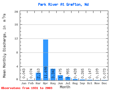
| Statistic | Jan | Feb | Mar | Apr | May | Jun | Jul | Aug | Sep | Oct | Nov | Dec | Annual |
|---|---|---|---|---|---|---|---|---|---|---|---|---|---|
| Mean | 0.04 | 0.07 | 2.16 | 11.70 | 3.34 | 1.48 | 0.95 | 0.43 | 0.27 | 0.15 | 0.11 | 0.07 | 1.74 |
| Standard Deviation | 0.07 | 0.18 | 3.80 | 13.29 | 7.66 | 2.43 | 2.18 | 1.92 | 0.84 | 0.35 | 0.16 | 0.10 | 1.73 |
| Min | 0.00 | 0.00 | 0.00 | 0.00 | 0.06 | 0.00 | 0.00 | 0.00 | 0.00 | 0.00 | 0.00 | 0.00 | 0.04 |
| Max | 0.39 | 1.29 | 18.53 | 58.08 | 58.64 | 16.31 | 12.49 | 16.10 | 5.25 | 1.98 | 0.89 | 0.49 | 9.98 |
| Coefficient of Variation | 1.75 | 2.43 | 1.76 | 1.14 | 2.29 | 1.65 | 2.29 | 4.49 | 3.16 | 2.38 | 1.49 | 1.43 | 1.00 |
 Return to R-Arctic Net Home Page