|
|
|||||||||||||||||
| Point ID: 9722 | Downloads | Plots | Site Data | Code: 05090000 |
|
|
|||||||||||||||||
| Download | |
|---|---|
| Site Descriptor Information | Site Time Series Data |
| Link to all available data | |
| View: | Time Series | All |
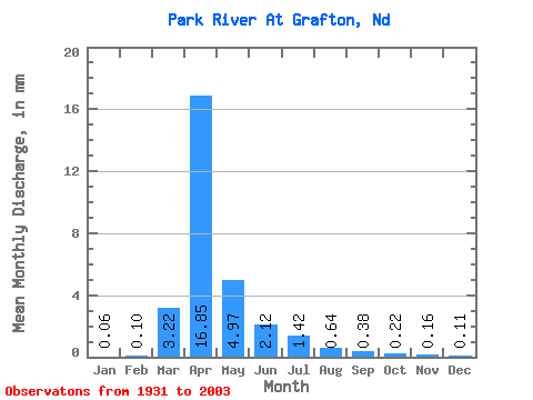
| Units: | m3/s |
| Statistic | Jan | Feb | Mar | Apr | May | Jun | Jul | Aug | Sep | Oct | Nov | Dec | Annual |
|---|---|---|---|---|---|---|---|---|---|---|---|---|---|
| Mean | 0.06 | 0.10 | 3.22 | 16.84 | 4.97 | 2.12 | 1.42 | 0.64 | 0.38 | 0.22 | 0.16 | 0.11 | 30.45 |
| Standard Deviation | 0.11 | 0.24 | 5.66 | 19.14 | 11.40 | 3.50 | 3.25 | 2.86 | 1.21 | 0.52 | 0.23 | 0.16 | 30.42 |
| Min | 0.00 | 0.00 | 0.00 | 0.00 | 0.09 | 0.00 | 0.00 | 0.00 | 0.00 | 0.00 | 0.00 | 0.00 | 0.66 |
| Max | 0.59 | 1.75 | 27.56 | 83.63 | 87.24 | 23.48 | 18.58 | 23.95 | 7.56 | 2.94 | 1.27 | 0.73 | 174.95 |
| Coefficient of Variation | 1.75 | 2.43 | 1.76 | 1.14 | 2.29 | 1.65 | 2.29 | 4.49 | 3.16 | 2.38 | 1.49 | 1.43 | 1.00 |
 Return to R-Arctic Net Home Page