|
|
|||||||||||||||||
| Point ID: 9716 | Downloads | Plots | Site Data | Code: 05132000 |
|
|
|||||||||||||||||
| Download | |
|---|---|
| Site Descriptor Information | Site Time Series Data |
| Link to all available data | |
| View: | Time Series | All |
| Units: | mm |
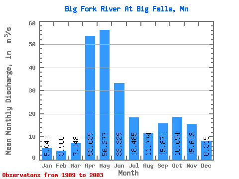
| Statistic | Jan | Feb | Mar | Apr | May | Jun | Jul | Aug | Sep | Oct | Nov | Dec | Annual |
|---|---|---|---|---|---|---|---|---|---|---|---|---|---|
| Mean | 5.04 | 3.99 | 7.15 | 53.64 | 56.28 | 33.33 | 18.48 | 11.77 | 15.87 | 18.69 | 15.61 | 8.31 | 20.54 |
| Standard Deviation | 2.73 | 2.15 | 7.84 | 31.43 | 35.34 | 21.25 | 15.30 | 10.43 | 14.96 | 14.24 | 10.70 | 4.88 | 8.76 |
| Min | 0.63 | 0.65 | 0.93 | 4.95 | 3.90 | 5.11 | 1.30 | 0.76 | 0.63 | 1.08 | 1.26 | 0.90 | 2.32 |
| Max | 11.29 | 9.49 | 54.60 | 146.85 | 212.27 | 81.84 | 65.72 | 50.96 | 84.63 | 63.63 | 57.60 | 19.38 | 38.63 |
| Coefficient of Variation | 0.54 | 0.54 | 1.10 | 0.59 | 0.63 | 0.64 | 0.83 | 0.89 | 0.94 | 0.76 | 0.69 | 0.59 | 0.43 |
 Return to R-Arctic Net Home Page