|
|
|||||||||||||||||
| Point ID: 9716 | Downloads | Plots | Site Data | Code: 05132000 |
|
|
|||||||||||||||||
| Download | |
|---|---|
| Site Descriptor Information | Site Time Series Data |
| Link to all available data | |
| View: | Time Series | All |
| Units: | m3/s |
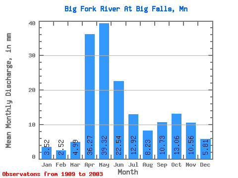
| Statistic | Jan | Feb | Mar | Apr | May | Jun | Jul | Aug | Sep | Oct | Nov | Dec | Annual |
|---|---|---|---|---|---|---|---|---|---|---|---|---|---|
| Mean | 3.52 | 2.54 | 4.99 | 36.27 | 39.32 | 22.54 | 12.91 | 8.23 | 10.73 | 13.06 | 10.56 | 5.81 | 169.11 |
| Standard Deviation | 1.91 | 1.37 | 5.48 | 21.25 | 24.69 | 14.37 | 10.69 | 7.28 | 10.12 | 9.95 | 7.24 | 3.41 | 72.10 |
| Min | 0.44 | 0.41 | 0.65 | 3.35 | 2.73 | 3.46 | 0.91 | 0.53 | 0.43 | 0.76 | 0.85 | 0.63 | 19.12 |
| Max | 7.89 | 6.04 | 38.14 | 99.30 | 148.30 | 55.34 | 45.91 | 35.60 | 57.23 | 44.45 | 38.95 | 13.54 | 318.05 |
| Coefficient of Variation | 0.54 | 0.54 | 1.10 | 0.59 | 0.63 | 0.64 | 0.83 | 0.89 | 0.94 | 0.76 | 0.69 | 0.59 | 0.43 |
 Return to R-Arctic Net Home Page