|
|
|||||||||||||||||
| Point ID: 9713 | Downloads | Plots | Site Data | Code: 05122000 |
|
|
|||||||||||||||||
| Download | |
|---|---|
| Site Descriptor Information | Site Time Series Data |
| Link to all available data | |
| View: | Time Series | All |
| Units: | mm |
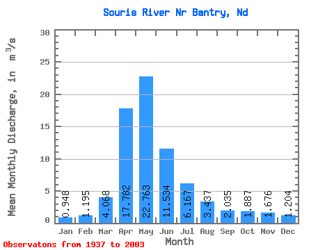
| Statistic | Jan | Feb | Mar | Apr | May | Jun | Jul | Aug | Sep | Oct | Nov | Dec | Annual |
|---|---|---|---|---|---|---|---|---|---|---|---|---|---|
| Mean | 0.95 | 1.20 | 4.07 | 17.78 | 22.76 | 11.53 | 6.17 | 3.44 | 2.04 | 1.89 | 1.68 | 1.20 | 6.37 |
| Standard Deviation | 1.03 | 1.83 | 5.87 | 25.30 | 33.05 | 15.79 | 7.85 | 4.79 | 2.59 | 2.00 | 1.41 | 1.13 | 6.83 |
| Min | 0.01 | 0.00 | 0.01 | 0.16 | 0.09 | 0.33 | 0.08 | 0.03 | 0.00 | 0.02 | 0.01 | 0.03 | 0.41 |
| Max | 4.94 | 10.99 | 25.81 | 160.43 | 146.15 | 79.88 | 45.75 | 30.58 | 17.93 | 11.94 | 6.19 | 4.86 | 33.67 |
| Coefficient of Variation | 1.09 | 1.53 | 1.44 | 1.42 | 1.45 | 1.37 | 1.27 | 1.39 | 1.27 | 1.06 | 0.84 | 0.94 | 1.07 |
 Return to R-Arctic Net Home Page