|
|
|||||||||||||||||
| Point ID: 9713 | Downloads | Plots | Site Data | Code: 05122000 |
|
|
|||||||||||||||||
| Download | |
|---|---|
| Site Descriptor Information | Site Time Series Data |
| Link to all available data | |
| View: | Time Series | All |
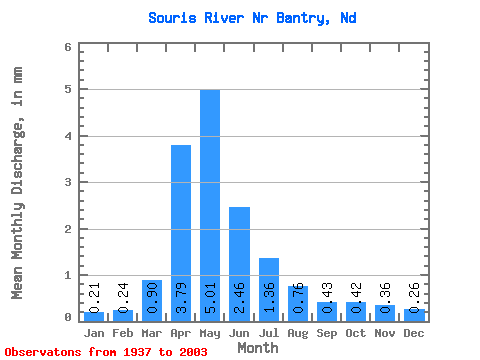
| Units: | m3/s |
| Statistic | Jan | Feb | Mar | Apr | May | Jun | Jul | Aug | Sep | Oct | Nov | Dec | Annual |
|---|---|---|---|---|---|---|---|---|---|---|---|---|---|
| Mean | 0.08 | 0.09 | 0.34 | 1.45 | 1.91 | 0.94 | 0.52 | 0.29 | 0.17 | 0.16 | 0.14 | 0.10 | 6.31 |
| Standard Deviation | 0.09 | 0.14 | 0.49 | 2.06 | 2.78 | 1.28 | 0.66 | 0.40 | 0.21 | 0.17 | 0.11 | 0.10 | 6.77 |
| Min | 0.00 | 0.00 | 0.00 | 0.01 | 0.01 | 0.03 | 0.01 | 0.00 | 0.00 | 0.00 | 0.00 | 0.00 | 0.41 |
| Max | 0.41 | 0.84 | 2.17 | 13.05 | 12.29 | 6.50 | 3.85 | 2.57 | 1.46 | 1.00 | 0.50 | 0.41 | 33.35 |
| Coefficient of Variation | 1.09 | 1.53 | 1.44 | 1.42 | 1.45 | 1.37 | 1.27 | 1.39 | 1.27 | 1.06 | 0.84 | 0.94 | 1.07 |
 Return to R-Arctic Net Home Page