|
|
|||||||||||||||||
| Point ID: 9690 | Downloads | Plots | Site Data | Code: 05058000 |
|
|
|||||||||||||||||
| Download | |
|---|---|
| Site Descriptor Information | Site Time Series Data |
| Link to all available data | |
| View: | Time Series | All |
| Units: | mm |
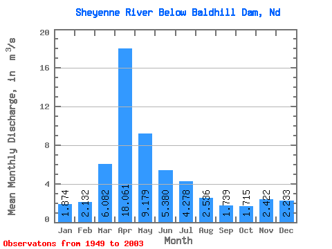
| Statistic | Jan | Feb | Mar | Apr | May | Jun | Jul | Aug | Sep | Oct | Nov | Dec | Annual |
|---|---|---|---|---|---|---|---|---|---|---|---|---|---|
| Mean | 1.87 | 2.13 | 6.08 | 18.06 | 9.18 | 5.38 | 4.28 | 2.54 | 1.74 | 1.71 | 2.42 | 2.23 | 4.82 |
| Standard Deviation | 1.39 | 1.91 | 9.18 | 21.59 | 14.12 | 6.46 | 6.16 | 6.23 | 2.92 | 2.66 | 2.76 | 2.10 | 4.31 |
| Min | 0.10 | 0.22 | 0.22 | 0.06 | 0.19 | 0.17 | 0.21 | 0.19 | 0.02 | 0.05 | 0.15 | 0.12 | 0.41 |
| Max | 6.44 | 8.50 | 44.37 | 94.28 | 82.29 | 32.68 | 36.01 | 44.04 | 16.33 | 17.61 | 16.62 | 10.61 | 15.28 |
| Coefficient of Variation | 0.74 | 0.90 | 1.51 | 1.20 | 1.54 | 1.20 | 1.44 | 2.46 | 1.68 | 1.55 | 1.14 | 0.94 | 0.89 |
 Return to R-Arctic Net Home Page