|
|
|||||||||||||||||
| Point ID: 9688 | Downloads | Plots | Site Data | Code: 05087500 |
|
|
|||||||||||||||||
| Download | |
|---|---|
| Site Descriptor Information | Site Time Series Data |
| Link to all available data | |
| View: | Time Series | All |
| Units: | mm |
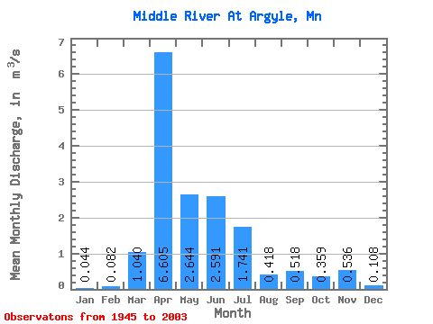
| Statistic | Jan | Feb | Mar | Apr | May | Jun | Jul | Aug | Sep | Oct | Nov | Dec | Annual |
|---|---|---|---|---|---|---|---|---|---|---|---|---|---|
| Mean | 0.04 | 0.08 | 1.04 | 6.61 | 2.64 | 2.59 | 1.74 | 0.42 | 0.52 | 0.36 | 0.54 | 0.11 | 1.43 |
| Standard Deviation | 0.05 | 0.29 | 1.90 | 6.64 | 3.94 | 4.43 | 3.18 | 1.17 | 1.45 | 0.62 | 2.12 | 0.15 | 1.14 |
| Min | 0.00 | 0.00 | 0.00 | 0.01 | 0.06 | 0.01 | 0.00 | 0.00 | 0.00 | 0.00 | 0.00 | 0.00 | 0.07 |
| Max | 0.25 | 1.98 | 9.48 | 27.34 | 25.37 | 18.68 | 19.47 | 7.49 | 7.71 | 2.66 | 15.15 | 0.63 | 5.53 |
| Coefficient of Variation | 1.19 | 3.56 | 1.82 | 1.00 | 1.49 | 1.71 | 1.83 | 2.81 | 2.81 | 1.74 | 3.95 | 1.40 | 0.80 |
 Return to R-Arctic Net Home Page