|
|
|||||||||||||||||
| Point ID: 9688 | Downloads | Plots | Site Data | Code: 05087500 |
|
|
|||||||||||||||||
| Download | |
|---|---|
| Site Descriptor Information | Site Time Series Data |
| Link to all available data | |
| View: | Time Series | All |
| Units: | m3/s |
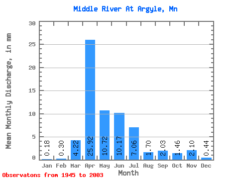
| Statistic | Jan | Feb | Mar | Apr | May | Jun | Jul | Aug | Sep | Oct | Nov | Dec | Annual |
|---|---|---|---|---|---|---|---|---|---|---|---|---|---|
| Mean | 0.18 | 0.30 | 4.22 | 25.92 | 10.72 | 10.17 | 7.06 | 1.69 | 2.03 | 1.46 | 2.10 | 0.44 | 68.50 |
| Standard Deviation | 0.21 | 1.07 | 7.69 | 26.06 | 15.96 | 17.39 | 12.90 | 4.75 | 5.71 | 2.53 | 8.32 | 0.61 | 54.59 |
| Min | 0.00 | 0.00 | 0.00 | 0.02 | 0.24 | 0.04 | 0.00 | 0.00 | 0.00 | 0.00 | 0.00 | 0.00 | 3.15 |
| Max | 1.01 | 7.30 | 38.46 | 107.32 | 102.86 | 73.33 | 78.97 | 30.38 | 30.27 | 10.80 | 59.47 | 2.55 | 264.44 |
| Coefficient of Variation | 1.19 | 3.56 | 1.82 | 1.00 | 1.49 | 1.71 | 1.83 | 2.81 | 2.81 | 1.74 | 3.95 | 1.40 | 0.80 |
 Return to R-Arctic Net Home Page