|
|
|||||||||||||||||
| Point ID: 9687 | Downloads | Plots | Site Data | Code: 05106000 |
|
|
|||||||||||||||||
| Download | |
|---|---|
| Site Descriptor Information | Site Time Series Data |
| Link to all available data | |
| View: | Time Series | All |
| Units: | mm |
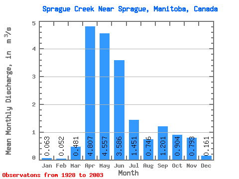
| Statistic | Jan | Feb | Mar | Apr | May | Jun | Jul | Aug | Sep | Oct | Nov | Dec | Annual |
|---|---|---|---|---|---|---|---|---|---|---|---|---|---|
| Mean | 0.06 | 0.05 | 0.48 | 4.81 | 4.56 | 3.59 | 1.45 | 0.75 | 1.20 | 0.90 | 0.79 | 0.16 | 1.77 |
| Standard Deviation | 0.05 | 0.04 | 0.93 | 3.99 | 4.00 | 5.04 | 1.86 | 1.10 | 2.29 | 1.36 | 1.78 | 0.18 | 0.98 |
| Min | 0.01 | 0.00 | 0.01 | 0.20 | 0.06 | 0.00 | 0.00 | 0.00 | 0.01 | 0.03 | 0.03 | 0.01 | 0.16 |
| Max | 0.29 | 0.21 | 5.46 | 17.93 | 20.07 | 35.06 | 8.93 | 4.54 | 11.87 | 7.33 | 13.02 | 0.85 | 4.25 |
| Coefficient of Variation | 0.81 | 0.72 | 1.94 | 0.83 | 0.88 | 1.41 | 1.28 | 1.47 | 1.91 | 1.51 | 2.25 | 1.11 | 0.56 |
 Return to R-Arctic Net Home Page