|
|
|||||||||||||||||
| Point ID: 9687 | Downloads | Plots | Site Data | Code: 05106000 |
|
|
|||||||||||||||||
| Download | |
|---|---|
| Site Descriptor Information | Site Time Series Data |
| Link to all available data | |
| View: | Time Series | All |
| Units: | m3/s |
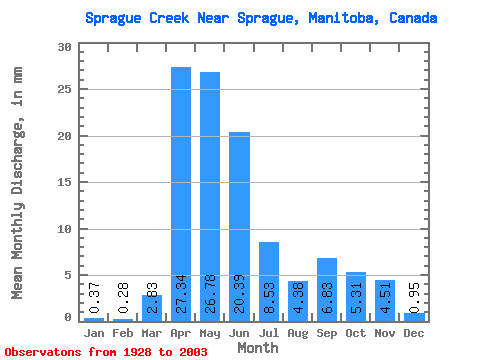
| Statistic | Jan | Feb | Mar | Apr | May | Jun | Jul | Aug | Sep | Oct | Nov | Dec | Annual |
|---|---|---|---|---|---|---|---|---|---|---|---|---|---|
| Mean | 0.37 | 0.28 | 2.82 | 27.34 | 26.77 | 20.39 | 8.53 | 4.38 | 6.83 | 5.31 | 4.51 | 0.94 | 122.50 |
| Standard Deviation | 0.30 | 0.20 | 5.49 | 22.70 | 23.50 | 28.65 | 10.92 | 6.44 | 13.04 | 8.01 | 10.12 | 1.05 | 68.06 |
| Min | 0.04 | 0.02 | 0.09 | 1.15 | 0.37 | 0.02 | 0.01 | 0.02 | 0.06 | 0.16 | 0.18 | 0.03 | 11.10 |
| Max | 1.72 | 1.11 | 32.06 | 101.96 | 117.89 | 199.40 | 52.44 | 26.65 | 67.50 | 43.07 | 74.02 | 5.01 | 293.94 |
| Coefficient of Variation | 0.81 | 0.72 | 1.94 | 0.83 | 0.88 | 1.41 | 1.28 | 1.47 | 1.91 | 1.51 | 2.25 | 1.11 | 0.56 |
 Return to R-Arctic Net Home Page