|
|
|||||||||||||||||
| Point ID: 9686 | Downloads | Plots | Site Data | Code: 05067500 |
|
|
|||||||||||||||||
| Download | |
|---|---|
| Site Descriptor Information | Site Time Series Data |
| Link to all available data | |
| View: | Time Series | All |
| Units: | mm |
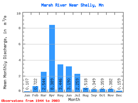
| Statistic | Jan | Feb | Mar | Apr | May | Jun | Jul | Aug | Sep | Oct | Nov | Dec | Annual |
|---|---|---|---|---|---|---|---|---|---|---|---|---|---|
| Mean | 0.11 | 0.72 | 2.54 | 8.39 | 3.45 | 3.19 | 2.26 | 0.52 | 0.35 | 0.36 | 0.38 | 0.16 | 1.80 |
| Standard Deviation | 0.34 | 3.84 | 4.24 | 10.51 | 9.97 | 7.55 | 4.32 | 1.54 | 0.84 | 0.77 | 0.88 | 0.46 | 2.71 |
| Min | 0.00 | 0.00 | 0.00 | 0.00 | 0.03 | 0.00 | 0.00 | 0.00 | 0.00 | 0.00 | 0.00 | 0.00 | 0.04 |
| Max | 1.83 | 25.70 | 21.36 | 43.51 | 74.10 | 46.55 | 23.22 | 10.27 | 4.07 | 3.68 | 4.43 | 2.18 | 15.51 |
| Coefficient of Variation | 3.16 | 5.32 | 1.67 | 1.25 | 2.90 | 2.37 | 1.91 | 2.98 | 2.41 | 2.15 | 2.29 | 2.87 | 1.51 |
 Return to R-Arctic Net Home Page