|
|
|||||||||||||||||
| Point ID: 9686 | Downloads | Plots | Site Data | Code: 05067500 |
|
|
|||||||||||||||||
| Download | |
|---|---|
| Site Descriptor Information | Site Time Series Data |
| Link to all available data | |
| View: | Time Series | All |
| Units: | m3/s |
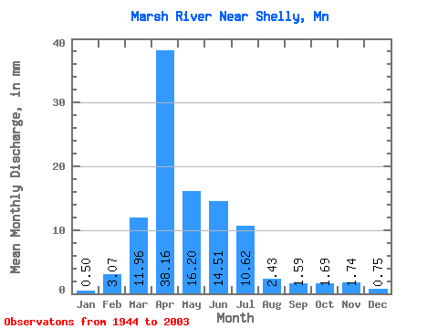
| Statistic | Jan | Feb | Mar | Apr | May | Jun | Jul | Aug | Sep | Oct | Nov | Dec | Annual |
|---|---|---|---|---|---|---|---|---|---|---|---|---|---|
| Mean | 0.51 | 3.09 | 11.96 | 38.16 | 16.20 | 14.51 | 10.62 | 2.43 | 1.59 | 1.69 | 1.74 | 0.75 | 99.62 |
| Standard Deviation | 1.59 | 16.45 | 19.91 | 47.81 | 46.88 | 34.34 | 20.31 | 7.25 | 3.81 | 3.62 | 3.99 | 2.14 | 150.31 |
| Min | 0.00 | 0.00 | 0.00 | 0.01 | 0.12 | 0.00 | 0.00 | 0.00 | 0.00 | 0.00 | 0.00 | 0.00 | 2.05 |
| Max | 8.59 | 110.04 | 100.40 | 197.94 | 348.26 | 211.75 | 109.15 | 48.27 | 18.52 | 17.28 | 20.14 | 10.26 | 859.01 |
| Coefficient of Variation | 3.16 | 5.32 | 1.67 | 1.25 | 2.90 | 2.37 | 1.91 | 2.98 | 2.41 | 2.15 | 2.29 | 2.87 | 1.51 |
 Return to R-Arctic Net Home Page