|
|
|||||||||||||||||
| Point ID: 9685 | Downloads | Plots | Site Data | Code: 05054500 |
|
|
|||||||||||||||||
| Download | |
|---|---|
| Site Descriptor Information | Site Time Series Data |
| Link to all available data | |
| View: | Time Series | All |
| Units: | mm |
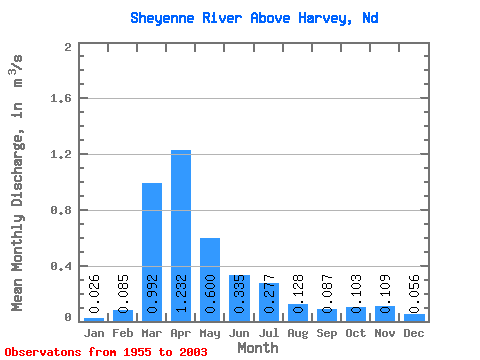
| Statistic | Jan | Feb | Mar | Apr | May | Jun | Jul | Aug | Sep | Oct | Nov | Dec | Annual |
|---|---|---|---|---|---|---|---|---|---|---|---|---|---|
| Mean | 0.03 | 0.09 | 0.99 | 1.23 | 0.60 | 0.34 | 0.28 | 0.13 | 0.09 | 0.10 | 0.11 | 0.06 | 0.34 |
| Standard Deviation | 0.05 | 0.16 | 1.23 | 1.64 | 0.77 | 0.44 | 0.44 | 0.28 | 0.20 | 0.16 | 0.17 | 0.10 | 0.33 |
| Min | 0.00 | 0.00 | 0.00 | 0.06 | 0.04 | 0.01 | 0.00 | 0.00 | 0.00 | 0.01 | 0.01 | 0.00 | 0.02 |
| Max | 0.19 | 0.76 | 5.87 | 9.19 | 3.31 | 2.19 | 1.91 | 1.68 | 1.37 | 0.98 | 1.10 | 0.60 | 1.22 |
| Coefficient of Variation | 1.74 | 1.91 | 1.24 | 1.33 | 1.28 | 1.31 | 1.59 | 2.19 | 2.33 | 1.53 | 1.60 | 1.81 | 0.98 |
 Return to R-Arctic Net Home Page