|
|
|||||||||||||||||
| Point ID: 9685 | Downloads | Plots | Site Data | Code: 05054500 |
|
|
|||||||||||||||||
| Download | |
|---|---|
| Site Descriptor Information | Site Time Series Data |
| Link to all available data | |
| View: | Time Series | All |
| Units: | m3/s |
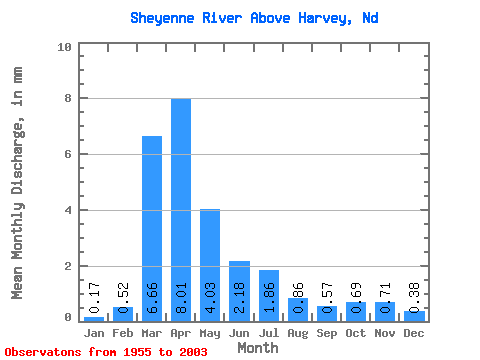
| Statistic | Jan | Feb | Mar | Apr | May | Jun | Jul | Aug | Sep | Oct | Nov | Dec | Annual |
|---|---|---|---|---|---|---|---|---|---|---|---|---|---|
| Mean | 0.06 | 0.19 | 2.42 | 2.91 | 1.46 | 0.79 | 0.68 | 0.31 | 0.20 | 0.25 | 0.26 | 0.14 | 9.67 |
| Standard Deviation | 0.11 | 0.36 | 3.00 | 3.88 | 1.88 | 1.03 | 1.07 | 0.69 | 0.47 | 0.39 | 0.41 | 0.25 | 9.44 |
| Min | 0.00 | 0.00 | 0.00 | 0.14 | 0.11 | 0.02 | 0.01 | 0.00 | 0.00 | 0.03 | 0.02 | 0.00 | 0.62 |
| Max | 0.47 | 1.68 | 14.31 | 21.68 | 8.06 | 5.17 | 4.65 | 4.10 | 3.24 | 2.38 | 2.61 | 1.46 | 35.16 |
| Coefficient of Variation | 1.74 | 1.91 | 1.24 | 1.33 | 1.28 | 1.31 | 1.59 | 2.19 | 2.33 | 1.53 | 1.60 | 1.81 | 0.98 |
 Return to R-Arctic Net Home Page